


I was wondering if anyone has alternate set ups using the 2nd 1942 board.
Like a 1940, 41, 43, ect…. Thanks.
I have the global 1939 map and I dont really like the 1940 global map so I was looking for alternate sey ups usuing the 1942 board.
I just was wondering if your going to still have the Japan tank blitz with the way less territories in Asia and Russia ?
If you don’t have AB in game you can always have Figs move 5. helps with Islands inside sea zones.
Good luck with this.
Interesting ideas about making the map safe for color-blind players, @Black_Elk. I’ll see about adding in some saturation contrast among the colors inside a faction, so that everyone can tell them apart. And yes, my goal is to keep the mechanics quite simple – I don’t know if you saw my other post about simplified subs, bombers, and interceptors, but I’m trying to minimize the number of exceptions and special rules: the territory values are what you see printed on the map, not what’s on the map plus a national objective. The combat values are what you see printed on the purchasing chart, not what’s on the chart plus special situational bonuses. I’ve got free rein as a designer to at least try to create a map that works out of the box, so hopefully that will help me push toward simplicity.
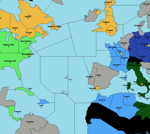
Along those lines, @SS-GEN, thank you very much for the suggestions, but, yes, my goal is to have japanese tanks blitz just like any other tank, and to have planes move 4 spaces from islands just like they move 4 spaces from any other territory. If I design the map tiles correctly, then adding in extra movement won’t be necessary, because islands will be naturally on the way from somewhere to somewhere else. If I design the Russian economy correctly, then nerfing Japanese units won’t be necessary, because Japan will be naturally checked and balanced by Russian armies.
I plan to put a starting minor factory in the Urals for the 1942 setup that can deadzone Siberia, which acts as a natural chokepoint, and in the 1939 setup (Khalkin Gol!) Russia will have tanks in eastern Siberia that outnumber and outpunch the starting Japanese forces. Note that even Manchuria is 4 spaces from Moscow. Buryatia and Kamchatka will not support a factory, I think, and Vladivostok & Korea are 5 spaces from Moscow. That’s enough room to have an interesting battle – the key will be making sure Russia has the factory locations, dollars, and starting troops to effectively oppose Japan without automatically losing against Germany. I think I can do that. I’ll keep you posted!
Yeah, although making a colorblind friendly map isn’t the goal in itself, its just a natural consequence of making better graphic design choices hehe. The stuff I’m talking about is very much for players with normal vision. Since our brains fixate on patterns and our eyes are drawn to contrast in any image, and because value is such an extremely powerful component in that, the first thing I’m drawn to in your draft (just like the WWII maps), is all the neutral tiles. So my eye darts around from Sweden to Arabia to South America etc, because that is where the highest value contrasts are occuring. There are lots of ways contrast can be used to highlight various focal points in an image, I just think that the standard WWII maps do a poor job of it, so I wouldn’t suggest following them as a model.
Instead I would set the primary value contrast between the land tiles and the ocean tiles, so the whole map reads well at a glance. If you have the variation on land be in the mid-range values, which can still be very dramatic at either end of the mids, you can eliminate the unseemly pops while still preserving the high contrast for something more relevant like you wanted between Axis territories and Allied territories.
I just brought it up since its a new map you are free to make a different color value choice for the ocean than they did for Revised/Global, which is now the default for all those WWII maps.
For sure, I read over the ideas on how to streamline and simplify, Russia balance etc and it all sounds good to me. Nice work
@Black_Elk said in Argo's Middleweight Map for 1939 & 1942:
So my eye darts around from Sweden to Arabia to South America etc, because that is where the highest value contrasts are occuring.
Ohh! OK, now I see what you were getting at. Yeah, you’re right, land vs. sea is an important place for contrast, and Axis vs. Allied is an important place for contrast, and relative to that neutral vs. impassible vs. owned is not a very important place for contrast, so it doesn’t make sense to use white for neutral or black for impassible or a greyish blue for the sea. Better would be grey for neutral, beige for impassible, and a very light, crisp cyan for the sea. Easy enough to fix!
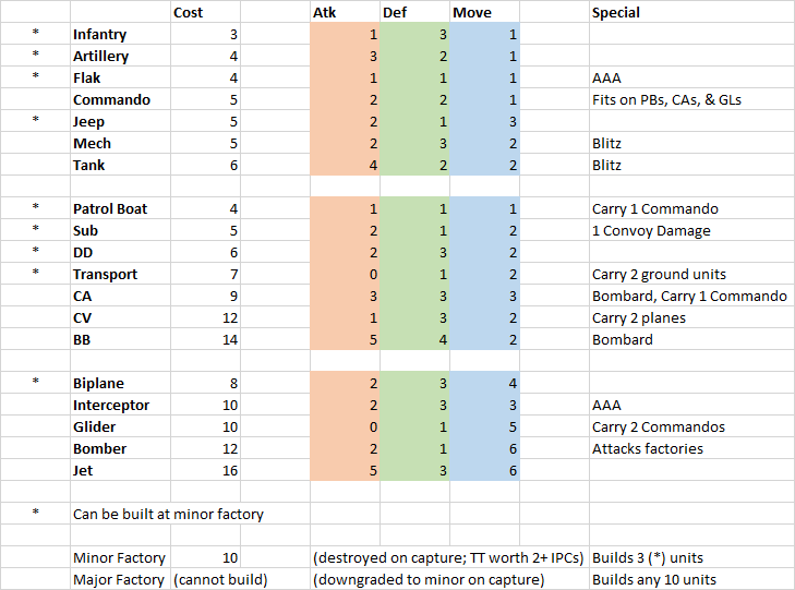
Early draft of unit chart. Note that artillery does not boost infantry, flak is not limited to non-combat move, transports are not defenseless, subs do not submerge, etc, fighters do not escort or intercept bombers – unless explicitly mentioned on the chart, special unit rules will not apply. This should help simplify the rules and allow newer players to enjoy the game even though there are more tiles and more unit types compared to Revised.
Now with territory values and a lighter color for the sea zone!

So I’m running into some difficulty, and I’m open to advice. At this point the map file is a .png file, as required for the TripleA map editor utilities; it’s not a vector file. That means that I can’t easily expand the size of the map (in pixels) while keeping the borders one-pixel wide, as required by the utilities.
Unfortunately, many of the smaller territories are not wide enough to accommodate even one or two unit types – the units are 35 pixels wide, so even though the map as a whole is several thousand pixels wide, smaller territories like Greece, Malta, Denmark, Kiev, etc. are just not capable of displaying a mixed army without spilling over way into other territories in a horrible mess. It’s not just one or two territories, and if I merged all of the smaller territories then this map would no longer faithfully represent my vision.
How have other map designers tackled this problem? Anyone have any creative ideas? I could start from scratch with a new vector file, but I would lose dozens of hours of work, even if I used this map as sort of a sketch to guide me.
I have very little knowledge of the graphics part. You might want to ask at the triplea site
https://forums.triplea-game.org/category/28/map-making
For some reason I want to say that units are usually 24x24 but I’m not certain about that. Also you can reverse the direction of the overflow if it’s less crowded going the other way.
Its not particularly easy. One of the reason I frequently reused sections of my world map for different projects is just because it took so damn long to redraw everything at scale initially and then rescaling is a pain. Your best bet is to double the scale to try and go from a 1 pixel border to a 2-3 pixel border when it rescales. When a raster graphics file like the one tripleA needs goes up or down in size, the shape of the line will change because you can’t recolor/fade the line to preserve the shape. The map can still function and there are ways to clean stuff up using map skins/details. See any of the tripleA maps based on Domination to get a sense for what that looks like. The map in that case will still usually still look reasonably good if players are running at a 50% zoom, though sometimes text can get harder to read and it may get some fuzz at different scales.
Otherwise you may be able to do more in Photoshop or Gimp by isolating the color (in this case black or white/blue) and expanding or isolating by 1 pixel. But you will almost certainly have to redraw something going that route, since it will give you gaps or chunky spots.
Basically this is one of the things that holds tripleA back as a game engine. There’s a lot you can do in tripleA, bit drawing/rescaling baselines is kinda stuck with what it is.
You might ask Frostion or Hepps about the tricks they use with map details to polish the borders. There are visual ways to soften things up so its not as pronounced.
Thanks for the tips, both of you! Just to be clear, I’m not worried at this point about the visual prettiness of the lines…I just need the lines to be thin enough and crisp enough that the Polygon Grabber can accurately identify territories.
@Argothair, put me down for helping in general with playtesting, naming territories, and GIMP/art stuff. What help do you need right now?
I just want to make sure that you know that Inkscape (free/open-source illustrator clone) can quickly and awesomely vectorize raster images- I’ve attached your map, vectorized as a pdf below (this took literally 5 minutes; you can endlessly tweak/refine the process, exclude text, etc…). You’re probably already aware- I just want to make sure. This obviously doesn’t instantly solve your 1-pixel-wide problems.
I think the Azores in the Atlantic has an expansive effect on Axis mental health (and strategic bombing strategies); what about in one of the two spots shown below?
@Black_Elk playing the POS map with the islands between SZs was just a massive eye-opener. I modified community maps and printed big physical POS & POS+C maps, and I taped your islands to my revised board- my group played 10 or 20 in-person games between 2006-2009 on those setups! So much crunchier tactically, especially in the Mediterranean and PTO, and the initial unit placements were so refreshing.
Top Azores is almost right. Same sz but move it more north and also be added maybe action if it was touching both sz. Mine is like that. I have uK convoy boxes out by Azores. Could place for either side to have plane support or sub attacks. Plus I know not interested but Azores is one of my influence strict neutral.
Hitler wanted to bomb Washington from there or close to it or naval ports
@SS-GEN said in Argo's Middleweight Map for 1939 & 1942:
Top Azores is almost right. Same sz but move it more north
I Northed the Azores. I think it would be fun to put them at the center of an intersection, would take some rejiggering. No clue how that affects atlantic flow.

I post pic of my map I use. You’ll see. For my game the battle of the Atlantic can go on for 6 turns. Be tough for this probably without changing setup a bit. But it’s just ideas u can store down the road for other games or to play around with. Depends on what convoy rules are being used.
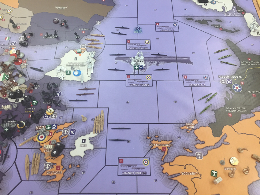
Here’s a pic of my setup in Atlantic. Disreguard Europe. There’s 3 more German subs not in pic. ! by Iceland, 1 by Norway and 1 in the Baltic. 13 total. So if a sub goes inside a convoy box it cost country that many ICPs against income and for every one sub touching the outside of a convoy box its another 1 Icp income lose.
There’s also another UK convoy box worth 2 not in pick at top of map and a Russian convoy box down below out of pick worth 4 by just east of Iceland.
Just some ideas if interested for other games.
I think we killed @Argothair’s thread with our Azorian chatter, @SS-GEN.
@vodot I don’t think so. I would believe he’s busy. I heard he’s not going to Siredbloods tourney this weekend.
@SS-GEN Yup, I’m just really busy. I’ll come back eventually!
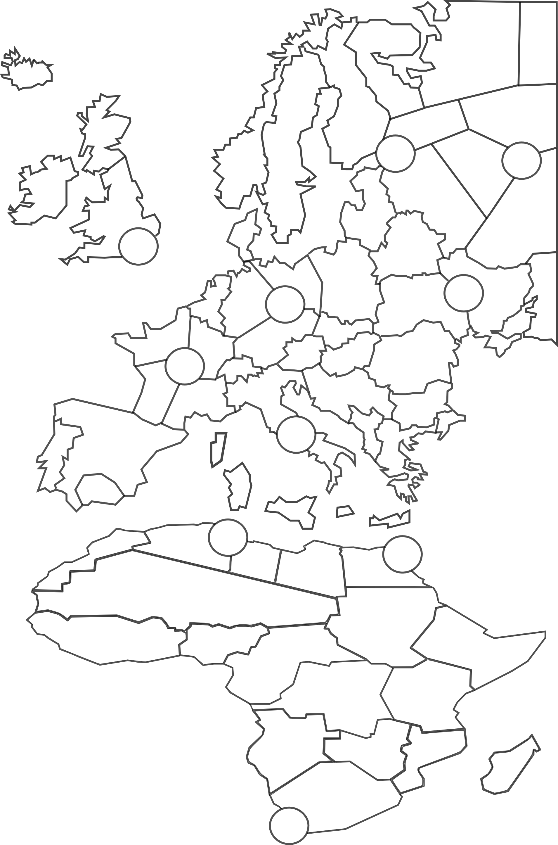
Update: I decided to manually trace a brand new vector map so that I can squash and enlarge continents as I see fit and then rescale when I’m done so that the smallest tiles will still be enough pixels wide to hold a few unit types each. Here’s Europe and Africa – you may notice that Africa is only half the height it ‘should’ be compared to Europe, and that the UK is about 140% of its proper size, and that the English Channel and North Sea are about triple their proper sizes. I plan to continue abusing geography for our wargaming convenience until I’ve finished the whole globe. This project is taking several years longer than I originally anticipated, but I do not plan to quit. Thanks again for all your support. :)
@Argothair said in Argo's Middleweight Map for 1939 & 1942:
This project is taking several years longer than I originally anticipated, but I do not plan to quit.
It’s nice to have a hobby :)

