


@yazoinkergrapft Yes, the United States is allowed to declare war. If it does, the sea zone immediately becomes hostile, as there are enemy surface warships in it. However, since the United States is not declaring war until the Collect Income phase, during the Combat Move, Conduct Combat, and Noncombat Move phases the sea zone is still friendly, so the United States can still occupy it freely. On Japan’s next turn, its units in the sea zone will be starting the turn in an enemy-occupied sea zone, so the normal rules for that situation apply (those units must either move away in combat movement or attack).
Northern Ireland
-
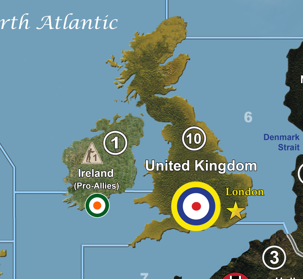
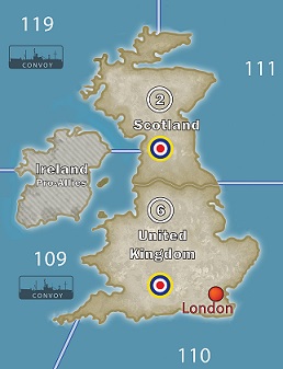
Well, my map is custom - I took out Scotland as I wanted more room for the UK capital and also more defense for the UK - only one land zone to defend - but Ireland is separated like this:
I know it was historically called Eire but I got tired of the guys looking at it blankly and trying to pronounce it.
-
Ok, sort of unrelated, but how do you customize maps?
-
The OOB map is definitely wrong to label the beige northeast corner of the island of Ireland as being part of Scotland – a gaffe that probably annoys the Scots as much as the Irish – and I also find that the map confuses things further by putting a British roundel on top of the straight that separates Ireland from Scotland, thus creating the impression that they are part of a single land mass. So in that respect, Der Kunstler’s customization is quite helpful. I think a further improvement would be to modify Ireland (which DK correctly shows to be an island) to make it look the way the Iberian Peninsula is depicted on the map: much of it consisting of Spain, which is one of the three types of neutrals in the game, but with a British enclave (Gibraltar) in one corner of its territory. “Ireland” is the name of the island as a whole; Eire is the name of the pro-Allied neutral Irish Republic that comprises most (but not all) of the island; and the British northeast corner of the island is called Northern Ireland. That would be strictly speaking the most historically accurate treatment – though not necessarily the optimal treatment in terms of game simplicity.
-
Ok, sort of unrelated, but how do you customize maps?
I customized mine by downloading one of Imperious Leader’s maps and using Photoshop, with his permission. Then you can take it to a printer and have them print it.
-
@CWO:
The OOB map is definitely wrong to label the beige northeast corner of the island of Ireland as being part of Scotland – a gaffe that probably annoys the Scots as much as the Irish – and I also find that the map confuses things further by putting a British roundel on top of the straight that separates Ireland from Scotland, thus creating the impression that they are part of a single land mass. So in that respect, Der Kunstler’s customization is quite helpful. I think a further improvement would be to modify Ireland (which DK correctly shows to be an island) to make it look the way the Iberian Peninsula is depicted on the map: much of it consisting of Spain, which is one of the three types of neutrals in the game, but with a British enclave (Gibraltar) in one corner of its territory. “Ireland” is the name of the island as a whole; Eire is the name of the pro-Allied neutral Irish Republic that comprises most (but not all) of the island; and the British northeast corner of the island is called Northern Ireland. That would be strictly speaking the most historically accurate treatment – though not necessarily the optimal treatment in terms of game simplicity.
Thanks for the proper info on that - IMO Northern Island is so small that for gameplay purposes it causes more problems to have there than it solves.
-
@Der:
@CWO:
The OOB map is definitely wrong to label the beige northeast corner of the island of Ireland as being part of Scotland – a gaffe that probably annoys the Scots as much as the Irish – and I also find that the map confuses things further by putting a British roundel on top of the straight that separates Ireland from Scotland, thus creating the impression that they are part of a single land mass. So in that respect, Der Kunstler’s customization is quite helpful. I think a further improvement would be to modify Ireland (which DK correctly shows to be an island) to make it look the way the Iberian Peninsula is depicted on the map: much of it consisting of Spain, which is one of the three types of neutrals in the game, but with a British enclave (Gibraltar) in one corner of its territory. “Ireland” is the name of the island as a whole; Eire is the name of the pro-Allied neutral Irish Republic that comprises most (but not all) of the island; and the British northeast corner of the island is called Northern Ireland. That would be strictly speaking the most historically accurate treatment – though not necessarily the optimal treatment in terms of game simplicity.
Thanks for the proper info on that - IMO Northern Island is so small that for gameplay purposes it causes more problems to have there than it solves.
I agree with that, dont really see the strategic value for gameplay purposes either with a Northern Ireland. Tho i really think Scotland plays a role and i will keep it! :) What do you guys think of the SZ border if Ireland is a single neutral territory island? Should the SZ border meet with the Scotish/UK land border or just meet the Scotish border so you can go from SZ 109 to Scotland?
-
On top of that it is silly to have the territory comprising of England and Wales be called “United Kingdom.” They could have just called it England (sorry Welsh).
-
This is how i made it, I think it will work ok! :)
-
Hmmm…I can’t see it - there’s just a black “X” there…
-
Sorry, bad link, fixed it! :)
-
Looks great!
Suggested Topics

