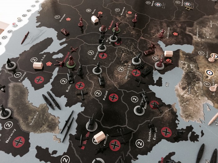
@vodot Yeah, definitely seems like the US would need some kind of economic boost if they have a split economy. I bet playing like this would be more historically accurate and more fun, especially with more than 2 players.
Supreme map 1942 ed 2
-
Thanks, but more than 95% of the work…comes from Dedo :wink:
-
Thanks, but more than 95% of the work…comes from Dedo
Don’t hide your light under a bushel, it’s extremely important to clear the faults otherwise one would chafe at the printed map when detecting the faults (in my first printed map I mixed up Western and Eastern Australia, it was an ongoing amusement to my game partner, an air traffic controller, to explain the difference between western and eastern again and again…).
-
I will be printing this for sure, perhaps next winter after my bunker renovations, I love how you corrected many of the graphic flaws that I had issues with.
@ YG, thank you very much, my pleasure!
BTW, good to know you with the 42.2ers! -
Just want to say thank you for the work on this, i printed it out at home, so much better than the oob and so much room…. grin The only issue i had was the seazones tended to blend. It may have been my printer, but anyway i will fix it with permanent marker. Thanks again
-
Insert Quote
Just want to say thank you for the work on this, i printed it out at home, so much better than the oob and so much room…. . Thanks againThank you very much, DM!
-
The only issue i had was the seazones tended to blend
What do you mean exactly? Is there a blending A) between the seazones (seazone borders between seazones are problematic) or B) within the seazones (bleeding of colors)? However, in the most cases, problems of a print out are related to the printer. If your computer screen shows you an accurate picture or graphic, the print out should be of the same quality (depending on the printer…).
A) When I remember right, the seazone border colors are predominantly white. Most of the standard printers (99%) do not print white. For example, try to print a white bar or something like this on colored paper, probably it will not work.
B) Bleeding: When I printed parts of the map the first time, I couldn’t find any bleedings. Again, bleedings may depend on your printer (I used a color laser printer). If you print the map on a standard printer, you should use the best solution and print quality possible.
-
the line between the seazones, as i say cheap printer, easy fix though.
-
To avoid confusions, the download links to older versions were deleted:
v01
v04
v07
v08
v14
v15
v22 -
I was looking at the map on page 4 and you really did a beautiful job, really superb. I clicked on the link in post #54 that said 5 of 5 but it said the image was temporarily unavailable. Was that the correct link or is there another link to this map?
Thank you :-)
-
Got it to work? :-D
-
Sorry for the late reply!
I tried it today and it worked. Perhaps your conncection was interrupted?
Bear in mind, that after clicking on the link you have to interrupt the automatic download and to click on the separate white download button in the upper right area of the window. -
Not to worry, I tried on a different PC and it worked just fine. Really is an excellent map, well done. :-)
I went to Staples and they gave me a price of like $60 for the 64x34 laminated. I’m leaning towards this unless I find it less expensive somewhere else. Thank you for the effort that was put into it.
-
Hi there,
Thanks for your beautiful design! I had this map printed on a 163x86 cm laminated canvas (3 mm thick) and the result is extremely satisfying. The size is almost the same with the G40 map. Thanks to ample zone space, there is no need to carry very crowded battles to the battle strip.
I took a few shots but cannot post links, this is my first post on the forums.
Best,
Emrah
-
Thank you for your friendly words, enjoy the game, it is much fun to play the big scale!
Unfortunately, posting fotos is not possible unless you gain some replies on any AAA-Forum (to avoid auto-spammers…). Feel free to send me a pm (personal mail), I can upload your fotos, if you like.
-
Emrah’s pictures 1/3


-
Emrah#s pictures 2/3


-
Emrah’s pictures 3/3


-
I’m confused.
Which map should I use, if I just want a bigger version of the map?
Sorry for being slow… :roll:
-
Please, describe what it is, that confuses you.
There are 5 maps, any one consisting of a landscape and several design features which differ between the maps. You can use any of the 5 maps, links to the maps are on p.2 and p.3 of this thread. -
It is the double triple border thing.
Is it the number of lines making up the border?


