To clarify, it’s the 2008 version in new condition but without the sealed wrapper
Custom map for AA50
-
Hi ! First of all, I am new here, so apologies if I do anything wrong ;)
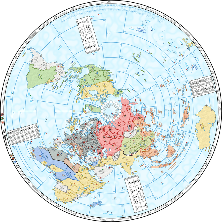
I wanted to share (a draft - low resolution) of my custom map for the anniversary edition (that I never saw or played). The original is a 155 cm diameter vector file - which is the size of my round table. I am planning to print it soon on neoprene, but wanted to check for eventual feedbacks before ;)
Despite Europe being already slightly oversized, the territories there are still quite small. Not smaller than the original though, so I guess it could do the job. I wanted to do it as historically accurate I could (with a focus on spring 1942, but the 1941 scenario can still be played in principle), so some territories are further splitted with dot lines - for cosmetic purposes only. Oh yeah, and it is labelled in French, apologies for that.
I wanted to keep it as close as possible to the original game, not to hamper the balance. Nevertheless, I made some changes that I hope don’t change much. In a nutshell :
- Changed names of many territories, just for fun (and/or accuracy)
- East Poland became Ukraine and Ukraine became Crimea, so I switched the IPC value between them to keep 2 IPC in Ukraine.
- Eastern Ukraine got an access to Azov sea. Planning to set a Kerch Straight rule with the need to own Caucasus to enter Azov sea (making this access pretty useless).
- Sea zones 15 and 16 are not connected (which should be irrelevant with Dardanelles rule).
- Panama is not connected to East Coast (no way to do that on a real map !) - but I don’t see how it would really impact the game.
- Himalaya and Sahara are not territories anymore, but replaced by a black line forbidding access (which should give exactly the same result) - added also Alps to restrict access between Italy and Germany without cheating with Switzerland’s size.
- Added a couple of additionnal neutrals (again without any in-game effects).
- Added Guianas as extra UK territory (but a 0 IPC territory on that corner of the map should really change anything)
All the rest is purely cosmetic OR room for optional house rules (not yet fully decided - can discuss them separately if anyone is interested) - but can be ignored to play the genuine game. For example Free French territories are by default administered by UK.
One last thing I am wondering about is SZ 26 (very ugly) - is it really used ? Can it really make any changes ? Otherwise I’d like to get rid of it.
Glad to read any kind of feedbacks if it inspires anyone ;)
-
@azimuth Pretty Map, only the bad thing it is in French!:confused:
-
@goekawar, well, yes. But I suppose you can identify most of the names, can’t you?
-
@azimuth that’s right, but it is common to use English for it,
-
@azimuth yea, as long as it’s not chinese or arabic, it’s not a problem. Although if one was chinese or arabic, it wouldn’t be a problem either : )
Good looking map
-
@goekawar, I got your point. But I’m sure that if you were playing, let’s say, a German game, and decided to customize the map, you’d have translated it in your language ;)
Do you guys have an opinion on sz 26? Is it really needed?
-
@azimuth I live in the Netherlands, I would never make a the game in Dutch. English I only should use as always.
-
@goekawar, OK, that’s your choice. Everybody is bilingual in the Netherlands, you don’t translate movies neither, I guess that’s your culture. 😉
-
vodot 2025 2024 '23 '22 '21 '18 Customizerlast edited by vodot Mar 10, 2023, 10:25 PM Mar 10, 2023, 10:21 PM
@azimuth Wow, this map is absolutely glorious. While I’m just as monolingual as most of my American brethren and would prefer it in English, the French is totally legible/guessable to me, and it’s such an awesome visual reminder of the internationality of the war. The detail here is phenomenal. Did you ever print it up? I have to see pictures of it in play! What about all of the cosmetic-only additions; do you find them visually distracting during actual play? To me this is on par with some of the other visually outstanding work that I would probably print more to hang as a piece of art than as a game board.
-
-
As an Italy player i like the Alpine impassable border
-
Thank you guys ;)
I am still working on this map (which looks already quite different than the version posted above).
I’ll keep you updated once I finally print it !
-
A Azimuth referenced this topic on Oct 12, 2023, 5:01 PM
-
@Azimuth I think SZ 26 is expendable. I would recommend setting up the starting units in Europe before too long – if the map is expensive to print, then you could try to just print the European part. If the pieces don’t fit in, e.g., Poland then the map is not useful as anything other than artwork.
I applaud your creativity in choosing a polar projection, but as you are noticing, having a round map makes it harder to minimize the oceans, and harder to minimize the southern hemisphere.
The only actual mistake I see on the map is that Khantys-Mansis and Siberia should be swapped – in real life, Siberia borders the White / Arctic Sea, and Khantys does not.
I could nitpick some of the territory values; I think the Soviet Far East should be worth $2 for gameplay purposes, Iran and Australia should be worth more for historical purposes, and so on, but that’s just my pet peeves; that’s not really specific to your map.
It’s very pretty! I hope you continue to enjoy creating it.
-
@Argothair, thank you for the feedback, very appreciated !
I made several print tests and corrected the design to ensure there was enough space in the small territories. Some place are really crowded (Baltic Sea…) but it fits - and it is not worse than on other OOB maps.
Agree that the polar projection is not the most rational, but I chose it on purpose. I’m lucky that the table is huge - plenty of empty oceans then where to place the trays and boards ;)
I note your remark on Soviet territories. Siberia seemed to me the best name for the “urban” oblasts of Tyumen, Omsk, Novosibirsk, Tomsk, Kemerovo and Krasnoyarsk (let’s say the “heart” of Siberia, as opposed to the autonomous ethnic “empty” districts). K-M covers the Khanty-Mantsi AOK, Yamalo-Nenetski AOK and Komi ASSR, but I don’t remember why I chose that name instead of another one. I’ll check for a better option.
Agree as well about IPC values, but those are OOB. I was planning to switch at least the 1 IPC “lost” by UK in Madagascar to Iran. Again this question “how deep do I want to change the original game”
-
Hi, folks.
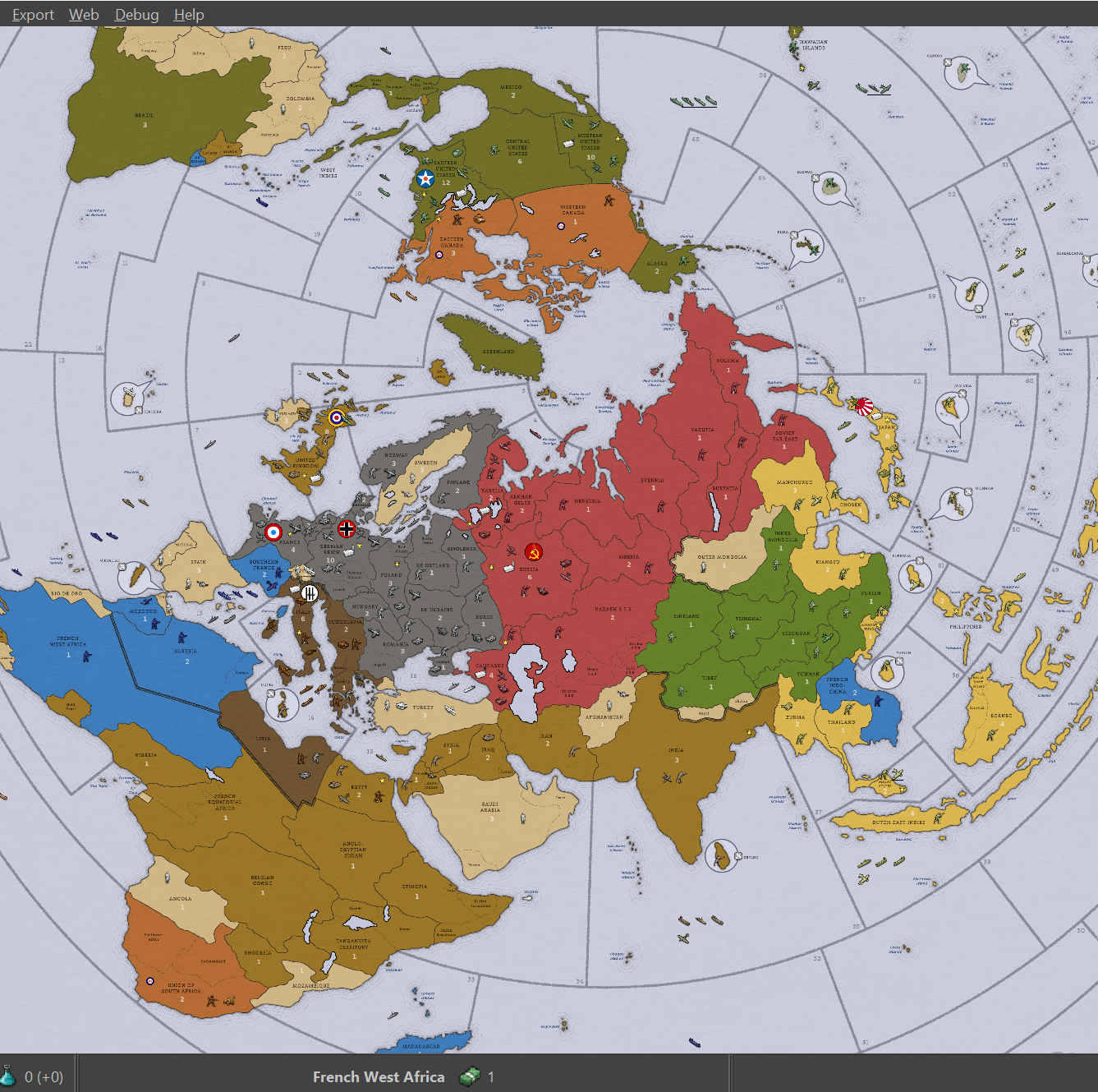
I initially started to mod the ww2v3 game in TripleA to test some of the house rules I wanted to play with my map. Like, to make sure I wouldn’t print it with game-breaking mistakes.
At first, I was using a roughly modified version of the game map. But after a while, I thought “why not use my own map”… and that became a new project in itself!
Here is a (purposedly blurry) glimpse of what it looks like so far :
I am testing several variants:
- OOB rules (1942 scenario) with just the modified map (including new straits rules), additional territories and adapted setup.
- Same but with a fully reviewed unit roster (including Tacs and Mechs)
Both variants have optional additional players (can be individually disabled before starting the game), with their own rulesets :
- French
- Commonwealth
- Neutrals
Not sure I’ll ever publish it… but I’m having a lot of fun ;)
-
@Azimuth wow, again, incredible! Keep it up!
-
A Azimuth referenced this topic on Feb 9, 2024, 3:57 PM
-
@vodot Thank you :)
You motivated me to open a separate post about the project:
-
@Azimuth Map looks great. If the final product is a PDF I’m sure someone could take the time to translate it for the community. My first thought though is how big do you have to print this thing to fit enough units into the territories of europe? You might want to skew the projection to make europe larger and africa and the america’s smaller to make it more playable.
-
@8d88 thank you for your message! Actually, the current project is quite far from the map I shared in the opening post. I twisted it already multiple time to increase space in Europe. I also printed several draft, and it fits (or at least, with similar constrains than the original map), because it’s total diameter is 155 cm (that’s big 😆). It also means that there are quite a lot of empty spaces on the table (which is useful for other purposes). But overall, this is all “for fun” and the design (polar projection) is definitely not the best for a game with an emphasis on Northern Hemisphere.
-
@Azimuth it caught my attention because I have a round table in the living room that’s about 120cm in diameter so I was thinking if a round map could work at that size it would be cool, but would require a lot of distortion I imagine. Would be curious to see where your map is at now.


