


Beautiful work @Argothair and @cloud7707
Custom Map
-
I will look into GIMP as well. Thank you for the input. My schedule filled up quickly so I lost most of what I thought would be free time to paint and customize a map, but I am still working to do both
-
Bgugs Thanks for starting this thread. Answered the questions I had. Thanks also to the community for its helpful answers.
But now that I’ve started…downloaded inkscape and gimp.
Does anyone know what the recommendation resolution needs to be? Specifically for larger map sizes like 4feet by 8 feet, or another common sized map at 3feet by 6feet. I would like it to have the same crisp image as either HBG 1936 or A&A global 1940. Since a digital cameras starting resolution affects larger images drastically, I assume the same here. I’d rather not pay to print a substandard large map, just to toss it and print again! -
@Rank:
Bgugs Thanks for starting this thread. Answered the questions I had. Thanks also to the community for its helpful answers.
But now that I’ve started…downloaded inkscape and gimp.
Does anyone know what the recommendation resolution needs to be? Specifically for larger map sizes like 4feet by 8 feet, or another common sized map at 3feet by 6feet. I would like it to have the same crisp image as either HBG 1936 or A&A global 1940. Since a digital cameras starting resolution affects larger images drastically, I assume the same here. I’d rather not pay to print a substandard large map, just to toss it and print again!You always want to print at 300dpi (dots per inch) regardless of the actual dimensions of the map. Just about any serious graphics program should allow you to set up your image by dimensions in inches or millimeters and by dpi, and that will determine your resolution in pixels.
-
Affinity Photo (Raster app comparable to Photoshop) and Affinity Designer (Vector app comparable to Illustrator) are the closest things you can get to professional software without the monthly or otherwise outrageous costs…roughly $50 each but worth it if you plan on using programs like this on a semi regular basis. Mac or PC, very powerful for the price and not too difficult to learn.
Make your files 300 dpi+ for printing. To check the “crispness” from a printer, send them a small square (maybe 3"x3") of the map with a lot of detail inside and have them print it as a test and check the quality. That way if it’s crap you’re only out a few $.
-
Thank you both! Mr tricorder and dillankid
Thats perfect info! :-D
Lots of threads on other’s project maps. But precious few, on how to DIY a map, player aids etc. The more you know, the fewer mistakes explained for you to repeat. -
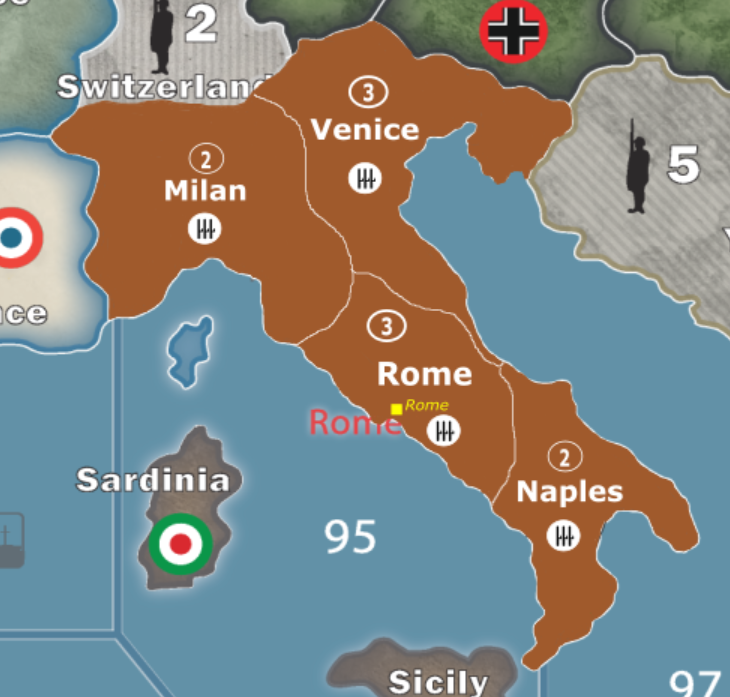
Working on Inkscape to customize a map. Here is Italy so far. There is little cosmetic things that need adjusting but its a start. Any suggestions?
-
Gorgeous bgugs!!! Keep it up.
-
Mr. Tricorder, you said you have used inkscape before. When working on this map it began placing white squares anywhere I attempted to draw. It wasn’t actually placing the blocks there just displaying them. What I mean is it would still draw the color I wanted where I wanted but would display a big white box over where I was attempting to draw until I zoomed either in or out. Because of this I tried to save my work and reopen it and see if that would work. Now when I reopen the file there is nothing there, not the original map or the map plus my edits. Any idea what may have happened?
-
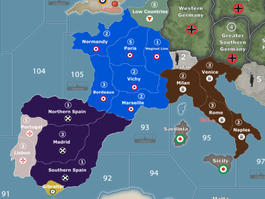
Here’s a look at how Western Europe is coming along
-
bgugs, that looks awesome! Great job on this. :-)
-
Thanks. I am trying for a more complex map with likely more complex house rules applied to a variant game. It likely will not be welcomed by many gaming groups but a game with more complexity and more variability fits my groups desire so that is the way I am going with my project.
-
Thanks. I am trying for a more complex map with likely more complex house rules applied to a variant game. It likely will not be welcomed by many gaming groups but a game with more complexity and more variability fits my groups desire so that is the way I am going with my project.
I here you. The more variants, the better for the community. :-)
-
You should consider adding Reims/Dunkirk to your map, bordering Low Countries (Belgium). A 1 shot deal into Paris is kinda defeating the purpose of your map
-
That’s still something I am torn on. I am worried about spacing and not making Europe overly crowded in certain territories, and I was kind of looking at making Germany have access to almost all of France once they conquer Belgium (much like they did in real life). I am still working on it and that is still something I am considering though
-
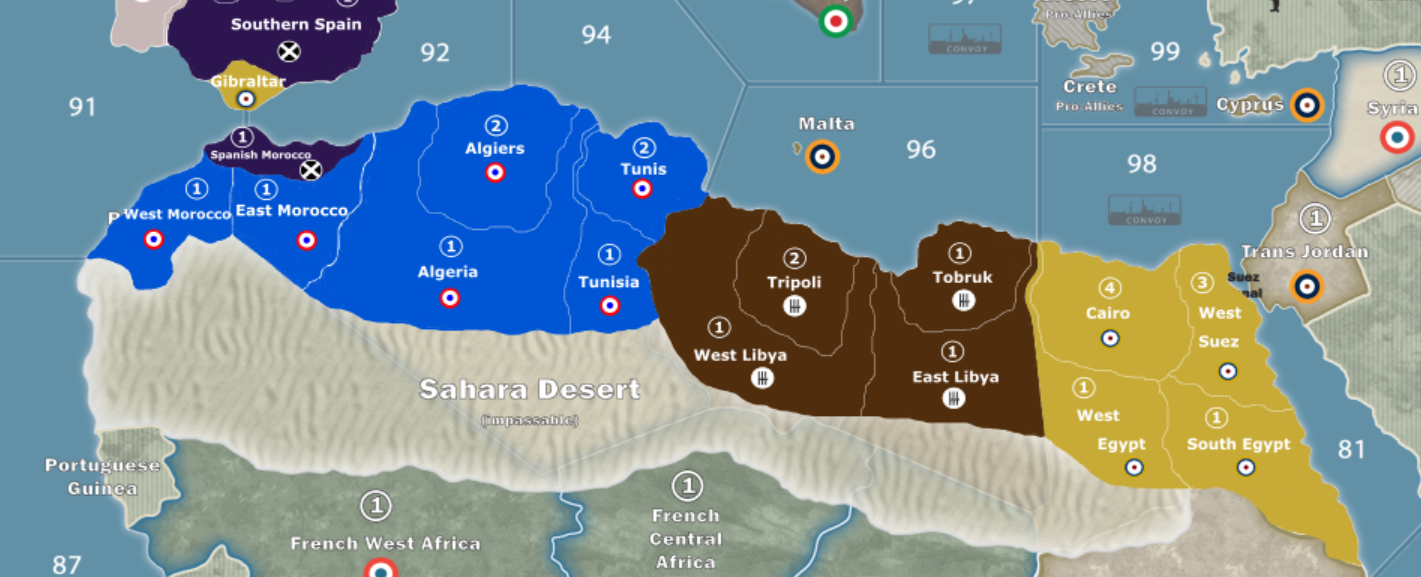
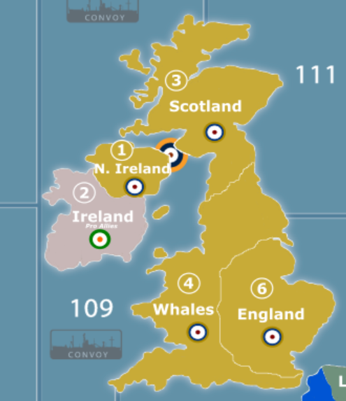
North Africa and Great Britain
-
North Africa and Great Britain
Nice maps. The Great Britain one, incidentally, should say Wales, not Whales.
-
That’s embarrassing, didn’t even notice that. Thank you!
-
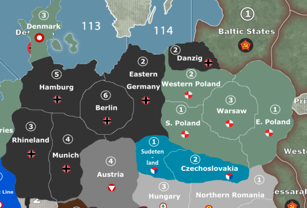
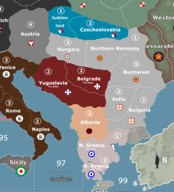
Been a while since I shared on here due to being busy and not having a lot to share, but here is Germany/Poland/Southern Europe
-
Mr. Tricorder, you said you have used inkscape before. When working on this map it began placing white squares anywhere I attempted to draw. It wasn’t actually placing the blocks there just displaying them. What I mean is it would still draw the color I wanted where I wanted but would display a big white box over where I was attempting to draw until I zoomed either in or out. Because of this I tried to save my work and reopen it and see if that would work. Now when I reopen the file there is nothing there, not the original map or the map plus my edits. Any idea what may have happened?
I’m very sorry. I haven’t visited this thread in a while and didn’t see your question until just now. I haven’t used inkscape in years though, so I don’t know what’s going on there. I have an Adobe Creative Cloud subscription, so I do all my vector-based artwork in Illustrator now. If you’re still having this problem, I would recommend checking out the inkscape support forums.
-
Not a problem. I was speaking to panther about the problem when it suddenly fixed itself. So now everything is working great
Suggested Topics

