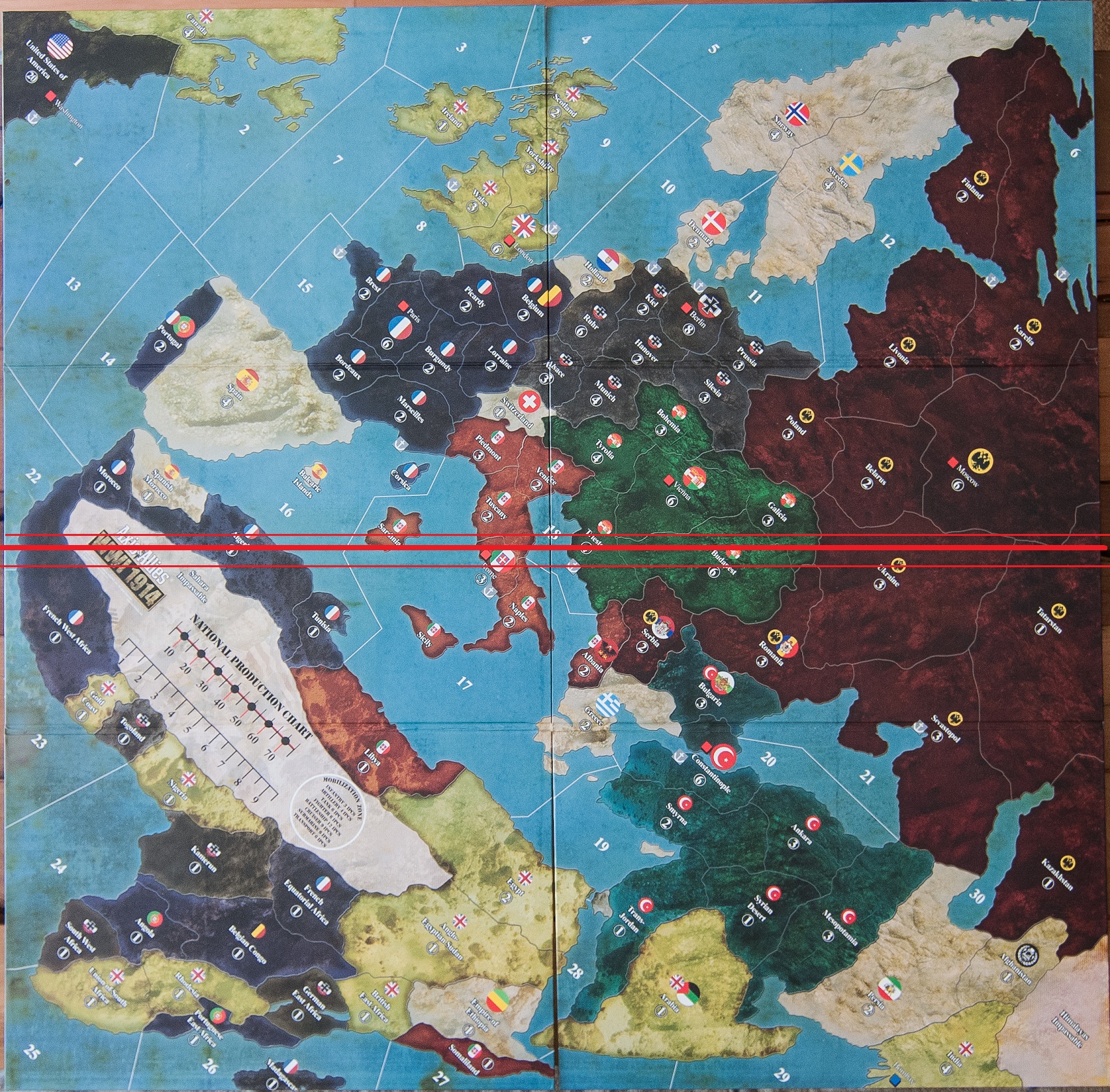
I’ve created a separate thread for my work on the OOB 1914 map. Please go here to discuss it in more detail.
Images of the Map?
-
Well, the 1940 boards didn’t exactly match up very well either (in colors or lines), what do you expect?
-
The boards should have run with the split going horizontal not vertical.
Instead of cutting through the western front, and all its clumped up territories, it could have ran South West to North East, through the Ukraine, Budapest, Italy, the Mediteranian, and the Sahara.
-
Probably would have been a good idea.
-
As it stands now the line bisects 13 land territories and 7 sea zones.
The other way the line would bisect 9 land territories (and Sahara) and 4 sea zones.
-
I though they’d sorted this type of production problem: had a big gap in my American Civil War board. Really no excuse for it.
-
It appears they worked hardest at matching Greece.
-
It appears they worked hardest at matching Greece.
Even though, arguably, they got the flag wrong:
-
Must be their anti-monarchist tendencies as Americans.
-
As it stands now the line bisects 13 land territories and 7 sea zones.
The other way the line would bisect 9 land territories (and Sahara) and 4 sea zones.
Yes very good point, Larry really has no help of this obvious stuff. Can’t count on WOTC to look at AA products with objective reasoning. It is too bad really.
-
I am sure it will be that bad or worse.
I am upset the dividing line doesn’t run the other way through the med and italy. Instead it runs smack dab through the western front!
What were they thinking!
Probably an attempt to represent the effect of all the Artillery. :-D
-
Does anyone know the significance of the Bombay victory city marker being blue as opposed to red like all the others? Thanks.
-
Yes, the UK is able to build an unspecified number of units there in addition to its capital. More details to follow I’m sure.
-
I don’t think Bombay is a VC, hence the different colour.
-
My latest custom version:
-
Is Spain a playable power in your version?
Which alliance would it be on?Any thoughts to which units it would start with?
-
Spain is neutral, and likely to remain so.
It would have a fleet off the NB at Cadiz.
-
My latest custom version:
I love it but I have one suggestion
Please divide “Küstenland” into Triest and Tirol.
There were two italien fronts in ww1 the alpine front in south tirol and the isonzo front towards triest.
Tirol is a wonderfull mountain region and should not be called a coast land.
-
I agree, but the two regions would be so small. Italian Tyrol and Istria barely show up on this scale, so I though of combining them into a single tt.
But I’ll look into this area again.
-
If any of you delightfully nefarious and crafty triple a programmers/designers are reading this, I have a potentially useful idea: Instead of having a big diamond shaped board with a bunch of wasted space around it, just rotate the whole map 45 degrees clockwise like the recent jpg, then rotate the territory names back to being parallel with the new bottom (southeast) edge. North wouldn’t be up anymore, but actual game play wouldn’t be affected and it would prevent many headaches. Southwest edge being the bottom would work too, of course.
good idea/bad idea?
please comment.
-
The map looks great, would love to play with more accurate territories.
For TripleA purposes rotating the board would make sense but it would be a little disorienting. The shoehorning of Africa in the game design is just too clumsy.
Perhaps the Caribbean could be added, gives another opportunity for Germany to pester the USA.
How about an incentive to wake up Spain and hand them back their lost island jewels?