


@derpsa As Germany you have to eliminate the Allied warships in Sea Zones 110 and 111. If you don’t sink these ships, the Allies will quickly be able to launch amphibious assaults against you. Then you’ll have a lot of trouble holding on to France and you’ll never make it into Russia.
A new look at the same picture.
-
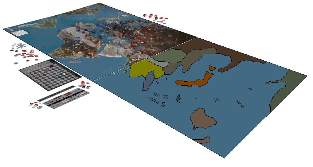
Ok, here one more I did the other day. Again, just to get a perceptive idea of what it would look like. Nothing to scale or detailed, just slapped together quickly for the what-it’s-worth department.
-
woah look at spain and portugal!!! do neutrals get troops now?
-
woah look at spain and portugal!!! do neutrals get troops now?
Some of them do, like the Mongolian tt.
-
Greenland looks ridiculous. its too close to Canada. Its nearly so far west that i think you can draw a straight line from it to Chicago.
-
@SAS:
Look at you being all clever! 8-) Pretty sweet!
was that an insult towards him, like look at you being clever like it`s like your like wow he did something clever :-P
-
@Imperious:
Greenland looks ridiculous. its too close to Canada. Its nearly so far west that i think you can draw a straight line from it to Chicago.
If you’re talking about the land in the corner, that’s Canada. The island barely overlaps the US
-
Important note……
It seems a US ship cant get to the UK in one turn from the east coast.
The liverpool area seazone seems to be 4 moves away from the US coast
It looks like US boats can get to Eire in one turn, but not into the saftey of dry land.
Therefore, for at least one turn US transports will be vulnerable to subamarine attack.
Likewise, no more “funnel” from eastern canada to UK a la revised/50thThe Funnel - (Move US units from eastern US to eastern Canada after building them. Transports run back and forth to France from Canada)
Iraq and Finland have a slightly different hue to them, likeley axis neutral special rules
Italy has an Albania territory.
The North Coast of Africa is - Morocco, Algeria, Tunisia, Lybia, Tobruk, Alexandria, Egypt
There are 2 Italain central African territories.
The “persia” area looks to be an “Iran”, Georgia, and Pakistan(ish) territories
Spain looks to be one territory, Turkey looks like it might be 2.
Sicily looks like it straddles 2 sea zones (no scrambling)
It doesnt look like there is room for both Corisica and Sardinia (perhaps they are very small, or one combined territory)
Hard to make out the Canadian roundel (gulp)
It looks like India will fit…however the chinese territories wont merge. -
Hard to make out the Canadian roundel (gulp)
- there will be a canada roundle on all but newfoundland.
@calvinhobbesliker:
@Imperious:
Greenland looks ridiculous. its too close to Canada. Its nearly so far west that i think you can draw a straight line from it to Chicago.
If you’re talking about the land in the corner, that’s Canada. The island barely overlaps the US
- no that not what he is talking about, look right and look at the lump on the edge of the board.
Newfoundland seems to have the same roundel.
- there will be a canada roundle on all but newfoundland.
-
Hard to make out the Canadian roundel (gulp)
- there will be a canada roundle on all but newfoundland.
@calvinhobbesliker:
@Imperious:
Greenland looks ridiculous. its too close to Canada. Its nearly so far west that i think you can draw a straight line from it to Chicago.
If you’re talking about the land in the corner, that’s Canada. The island barely overlaps the US
- no that not what he is talking about, look right and look at the lump on the edge of the board.
Newfoundland seems to have the same roundel.
I think you mean the Canadian one, if so that is the British one for sure
- there will be a canada roundle on all but newfoundland.
-
@Imperious:
Greenland looks ridiculous. its too close to Canada. Its nearly so far west that i think you can draw a straight line from it to Chicago.
Chicago is a bit too far, somewhere in between Cleavland and Philly.
-
@Dylan:
Hard to make out the Canadian roundel (gulp)
- there will be a canada roundle on all but newfoundland.
@calvinhobbesliker:
@Imperious:
Greenland looks ridiculous. its too close to Canada. Its nearly so far west that i think you can draw a straight line from it to Chicago.
If you’re talking about the land in the corner, that’s Canada. The island barely overlaps the US
- no that not what he is talking about, look right and look at the lump on the edge of the board.
Newfoundland seems to have the same roundel.
I think you mean the Canadian one, if so that is the British one for sure
You’re right; I was wrong.
- there will be a canada roundle on all but newfoundland.
-
Very very clever. Map looks nice from this view. Can’t wait to see the real thing! :-)
-
Very very clever. Map looks nice from this view. Can’t wait to see the real thing! :-)
yeah then I can zoom in and just put my head on the bored, and it will be a high resolution one :-D
-
Ok, here one more I did the other day. Again, just to get a perceptive idea of what it would look like. Nothing to scale or detailed, just slapped together quickly for the what-it’s-worth department.
Why is Australia upside down?
-
You kids know that this IS NOT the start up set up right?
-
You kids know that this IS NOT the start up set up right?
are you talking too me, do I look stupid.
-
Greenland being too close to Canada. It is actually less than 40 KM away from Canada’s ellesmere island, though that is much further north than shown on the map. From the look of the gamemap it looks like the Canuck territory Nunavut is shown next to greenland, in that case its about 325 KM away, about the same width (east-west) of Lake ontario or erie.
Now as far as being able to draw a straight line from Greenland to Chicago, can’t you draw a straight line between any to places on a map? wg Now if you drew a line straight north of Chicago to the north pole it would cut Hudson’s bay roughly down the middle. It also come within about 325 KM from the western tip of Greenland.
Projecting a curved surface onto a flat one always makes the northern territories distorted (northern hemisphere anyways). The map is a bit off but not too bad really.
I can’t see what roundel Newfoundland has but it should be British. Newfoundland was a British territory until 1949 when it joined Canada.
Thats dumb, Nunavut shouldn`t be a territory, it was part of Northwest Territory till 1999.
-
I didn’t mean to imply nunavut was a territory then… I was merely pointing out where the relative positions were using todays geographical terms.
-
I didn’t mean to imply nunavut was a territory then… I was merely pointing out where the relative positions were using todays geographical terms.
Is Northwest Territory in, because they put freaking Yukon in.
Suggested Topics

