


1940 europe
Turn Order?
-
The red dots act as both the victory cities and capitols. I could make a change to show London, Berlin, Moscow, Rome and Washington D.C. more clearly though. All the territory names and IPC values have already been determined and I will get them onto the map asap. Thanks Brain.
I eagerly await seeing the new map.
-
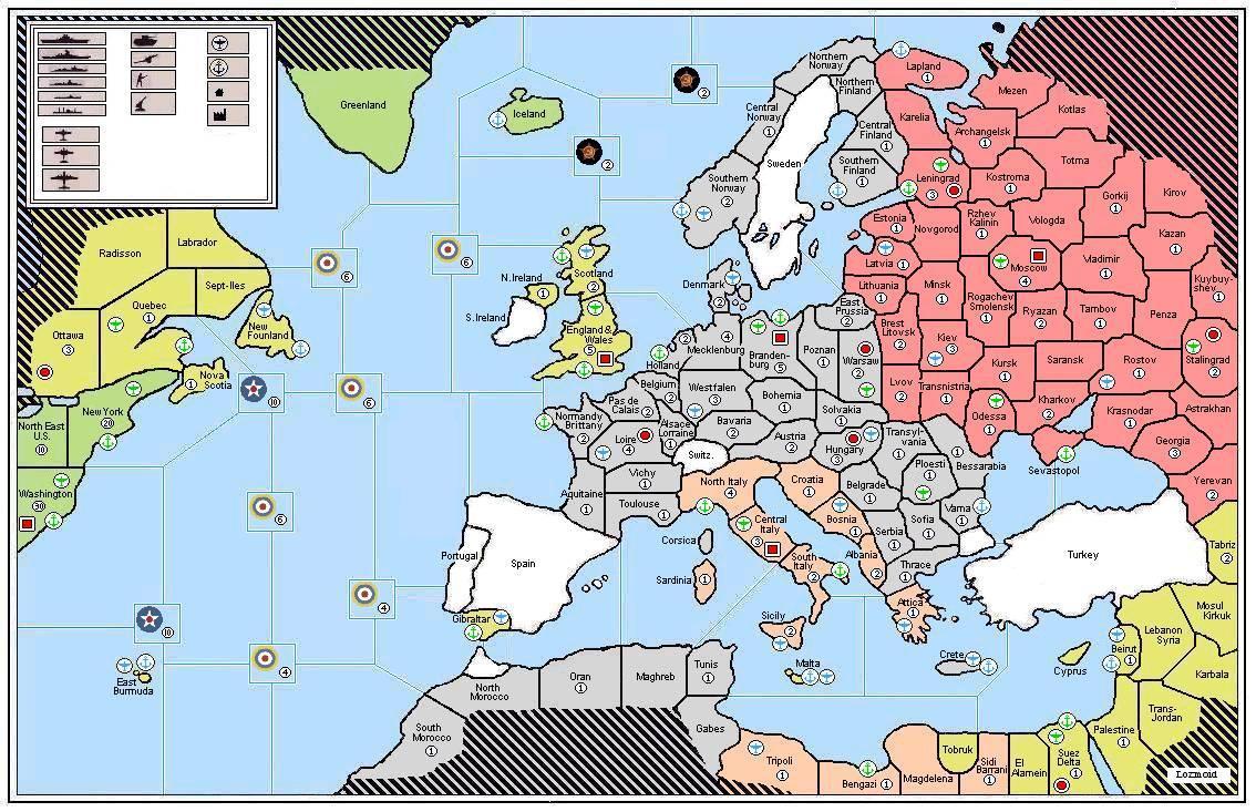
Right, here we go. Capitols now more obvious, territory names and IPC values in place. Let me know if you spot anything incorrect or omitted by accident… Thanks!

-
What is the difference between the blue and green plane icons?
-
The blue installations are minor; the green major. This is a home made game of A&A Europe 1941 I am designing. Just working out the unit set ups.
-
The blue installations are minor; the green major. This is a home made game of A&A Europe 1941 I am designing. Just working out the unit set ups.
Are the neutrals going to have IPC value?
-
Nova Scotia is not an island
-
Hi guys. Nope, the neutrals will stay neutral in my game. And I have now fixed the Nova Scotia issue; thanks for pointing that out.
-
Newfoundland, not New Founland. :wink:
-
How large is the map going to be when it is printed?
I am trying to get an idea of how large the territories are going to be,
-
@i:
hey wouldnt there be a naval base in halifax
quebec is getting an ic and the naval base. so the mouth of the saint lawrence has access to the atlantic.
nova scotia might me a part of the quebec territory, but if it is not there is no need to have 2 territories side by side, both with naval bases.
-
Hi all, the map prints out onto 16 sheets of A4 paper; I don’t know the exact dimensions of that though. It’s much bigger than the AA50 map.
Thanks for the correction on New Foundland; my typo there. Nova Scotia is connected to Quebec. Quebec will start the game with a Minor IC.
-
Hi all, the map prints out onto 16 sheets of A4 paper; I don’t know the exact dimensions of that though. It’s much bigger than the AA50 map.
Thanks for the correction on New Foundland; my typo there. Nova Scotia is connected to Quebec. Quebec will start the game with a Minor IC.
A4 paper size is 8.27 X 11.69 inches.
-
Once i saw the first post i thought to myself, Germany better go first! I mean that wouldn’t make sense.
-
Hi all, the map prints out onto 16 sheets of A4 paper; I don’t know the exact dimensions of that though. It’s much bigger than the AA50 map.
A4 paper size is 8.27 X 11.69 inches.
So I am guessing that the map is 32.08 x 46.76 inches
-
Thanks Brain, that would be about right. Although, not quite large as that because I has to trim the edge of the paper right to the map border (along the top and bottom half). But before you print it, make sure you go to page set up and set the size to fit ‘4 by 4’ on A4. Obviously, if your printer can do A3 then go ahead and do that. Well, it only just fits on my table. But the good thing is, the territories are pretty big.
-
Depending on how much trimming you’ve done, you may be able to use E size paper which is 34" x 44."
-
Yeah, that is a possibility. But hey, I’ve already printed it and taped it all together. Working on the set up now, will post a pic soon… It’s looking awesome to say the least! :-)
-
Yeah, that is a possibility. But hey, I’ve already printed it and taped it all together. Working on the set up now, will post a pic soon… It’s looking awesome to say the least! :-)
I will eagerly await.
-
@Dylan:
So i guess Canada is not a power
No. It’s officially been ruled out and there wasn’t much hope for it anyway.
-
How did this thread turn into another “Canada was excluded” thread.
This Canada thing has become spam or some kind of a virus infecting all the threads.
Canada will still be in the game, it just won’t be a seperate power.
Suggested Topics

