


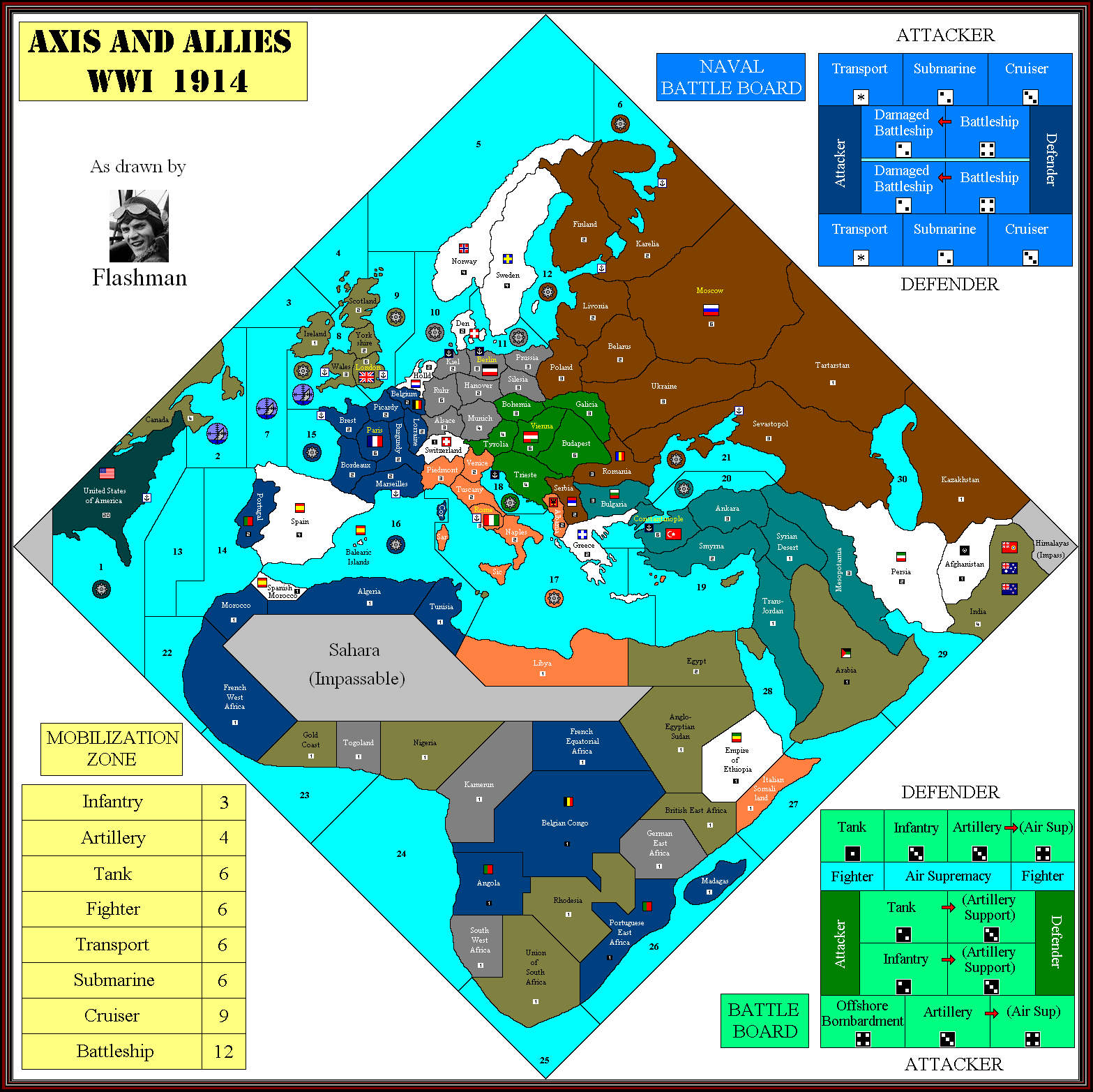
I’ve created a separate thread for my work on the OOB 1914 map. Please go here to discuss it in more detail.
Images of the Map?
-
Again, forget that the territory named “Poland” is named “Poland.” If it were given a generic name like “West Russia” it wouldn’t be as big of an issue that it has a baltic coastline. Granted, its weird that Germany doesn’t have all of Prussia, but I’ll say it again, the map is distorted for playability reasons.
It’s possible to make the game playable and balanced without resorting to distortions like taking East Prussia off the map and including it in a region called ‘Poland’.
-
Fair enough, I guess I am so excited about the game right now that I can overlook these map issues- If I want to look at a map I’ll look on google maps or an atlas.
-
@CWO:
Poland has a coast line in 1914… that’s news to me.� Prussia should boarder the “Livonia” province and Poland should be land locked.
It’s even arguable whether Poland should be there at all. Poland was partitioned between Russia, Austria and Prussia back in the 18th century, and it didn’t re-emerge as an independent state until after WWI. I don’t know if any of the three partitioning powers (Russia, Austria and Prussia) used “Poland” as an official regional name for their piece of Poland’s territory between 1772 and 1919. My understanding is that Tsarist Russian tried hard to suppress anything that smacked of Polish nationalism.
Alexander II actually gave Poland some self autonomy during the Great Reforms but because a lot of Polish noblemen revolted, after being denied more autonomy than what the Tsar
was willing to give, it was then brutally suppressed and had all of its autonomy taken away again. The region was still referred to as ‘Poland’ because Poles were subjected to different laws
than what Russians were.
-
@Hitlers:
Alexander II had actually gane Poland some self autonomy during the Great Reforms but because a lot of Polish noblemen revolted, after being denied more autonomy than what the Tsar was willing to give, it was then brutally suppressed and had all of its autonomy taken away again.
Reminds me of an old joke: a royal advisor goes to see the king and says in great agitation, “Majesty, the peasants are revolting!” The king casually answers, “Yes, I quite agree.”
-
Fair enough, I guess I am so excited about the game right now that I can overlook these map issues- If I want to look at a map I’ll look on google maps or an atlas.
I understand perfectly. I just want a ww1 A&A game, I really don’t care if Poland has a coastline or Bulgaria doesn’t, as long as I get the game. Though I will concede that a landlocked Poland would have added a slight strategic shift in thinking for the Russian player, It’s still not enough to make me really care.
-
Greece having a border with Constantinople (which it shouldn’t) should matter to you since it provides the Allies with an unexpected gateway into the Turksih capital.
-
It’s all the same sea zone so I really don’t see what difference it would make….If you can amphib into Bulgaria you might as well go a millionth of an inch over and amphib into Constantinople.
-
But Greece is likely to be less well defended, and from there you can attack Constantinople over land. There’s nothing the Turks can do about this other than invading Greece and adding 4 units to the Allies. With correct Bulgaria, they can use that tt as a front line against the Allies.
-
Or they can let the Allies invade and take the damage from 4 extra ottoman units and then constantly just pump reinforcments over from 1 whole province away. Not to mention with only 2 transports in the region, it would take a small mirical of the dice for the Allies to actually threaten the Ottomans from Greece. And if the situation is one where the allies can afford a large fleet of transports for more units…then it’s likely that the Centrals have already lost.
-
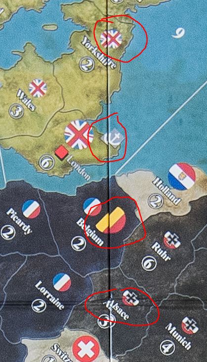
Are these micro dice?
-
I assume its the 12mm size, like in this chessex box.

-
For completions sake the final update:
Just spotted the SZ 22 border needed changing.
-
MVP award to Flashman for his excellent map work over the past months.
Thanks again, Flashman :-)
-
Hmm, looking at the pic it seemed that the dice were quite small compared to the chips.
-
I have to agree with wove100
Thanks Flashman for the previews
-
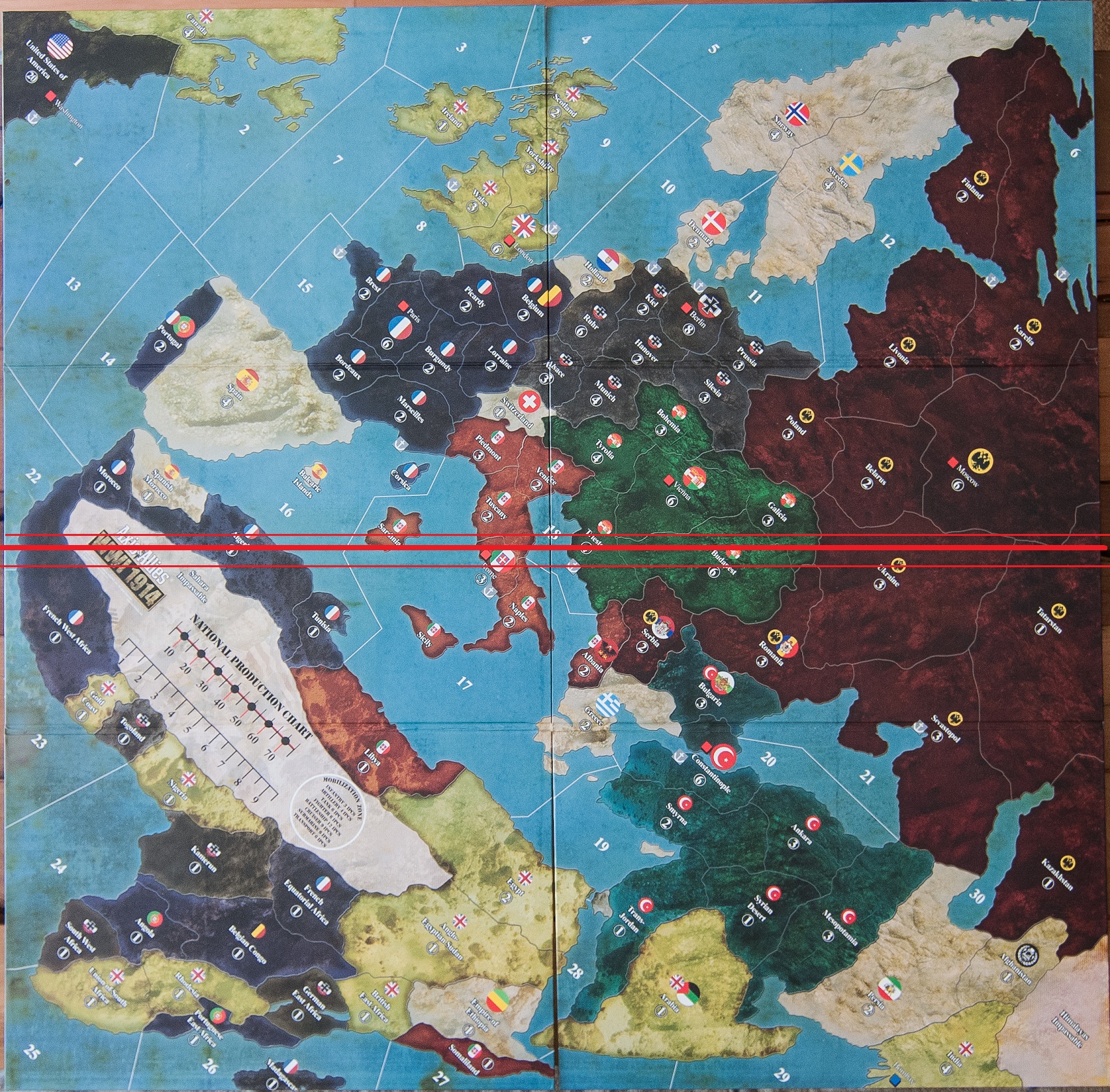
Really not happy with the quality of the dividing line between the two boards; see attached. My 8 year-old niece could do a better job making those match up. Hope this is just a ‘prototype’ board that djensen got a hold of, not the production model.
-
I am sure it will be that bad or worse.
I am upset the dividing line doesn’t run the other way through the med and italy. Instead it runs smack dab through the western front!
What were they thinking!
-
Well, the 1940 boards didn’t exactly match up very well either (in colors or lines), what do you expect?
-
The boards should have run with the split going horizontal not vertical.
Instead of cutting through the western front, and all its clumped up territories, it could have ran South West to North East, through the Ukraine, Budapest, Italy, the Mediteranian, and the Sahara.
-
Probably would have been a good idea.
Suggested Topics

