


I’ve created a separate thread for my work on the OOB 1914 map. Please go here to discuss it in more detail.
Images of the Map?
-
Flashman, can you make out more of the map from the ‘6 second box opening’?
-
Flashman, can you make out more of the map from the ‘6 second box opening’?
I don’t think anyone can with the speed of that video. I tried to pause it but couldn’t figure out how. I swear, that thing’ll give someone a seizure.
-
just click on the picture and it pauses
-
-
Ohh, RIGHT click.
Thanks, guys. I was only left-clicking.
-
Right click doesn’t work for me (proud Opera user), so i print-screened a couple times into paintbrush.


I’ll say, those transport ships and biplanes look AMAZING. The cruiser and dreadnought, not so much. The tanks are eehh… very blocky.
-
The transports look like freaking ocean liners. Terrible
-
Some WW1 transports had been converted from commercial ships, but I agree that a more military look would have been better.
-
New Italy, looks rather silly.
All to block an impossible Austrian AA on Rome…
Can’t pause the video; if anyone can make out a list of IPC values I’ll update.

-
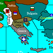
For my own version, I’ve decided that the only way to represent the political situation of Greece is to divide it into two tts.
After all Macedonia was only part of Greece for a year, and clearly had completely different sympathies:
http://en.wikipedia.org/wiki/Greek_Macedonia#Modern_history
I need to find out what Crete was doing in the war, can’t find anything yet.
Edit: seems Crete was part of the “Macedonian” pro-Allied state:
http://en.wikipedia.org/wiki/Salonika#20th_century
Which leaves me with: (map2)
Question is, if the Allies move into Macedonia, does pro-German Greece automatically mobilize against them?
-
thats only a question in your game…
In the real world according to international law Greece was one state that included Macedonia so of course a landing of british or french troops has to be seen as what it was, a violation of neutrality even clearer than the case of Belgium that wasn´t that neutral - even on this gameboard its frenchblue instead of neutral white. -
thats only a question in your game…
In the real world according to international law Greece was one state that included Macedonia so of course a landing of British or French troops has to be seen as what it was, a violation of neutrality even clearer than the case of Belgium that wasn’t that neutral - even on this gameboard it’s French blue instead of neutral white.Actually, Serbia controlled part of Macedonia at the time as well. Although I agree that Belgium should probably have a neutral marker, since it hasn’t been invaded by Germany yet on the board. Belgium wasn’t blatantly pro-Allied at the start of the war, and the German general staff believed that they would do nothing more than make a show of force to display their neutrality before allowing the German armies through.
-
Venizelos was the legitimate Prime Minister of Greece, so if he invited the Allies in how is that a breach of neutrality?
-
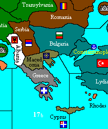
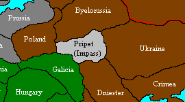
Back to the official map, the only change I can see from the vid pics is that Ukraine borders Poland:
On my version this is a moot point as the Pripet marsh occupies this area.
-
Constantinople is worth 6, Ankara and Mesopotamia are each worth 3.
-
Venizelos was the legitimate Prime Minister of Greece, so if he invited the Allies in how is that a breach of neutrality?
… and the head of state King Konstantin didn´t allow the Entente to operate in his country
so it doesn´t matter if they were “invited” by previously bribed Prime Minister VenizelosThe French and British troops that marched into Greece for preparing the landing at Gallipoli, specifically on the island of Tenedos and in Salonika in 1915 did according international law the same thing what germans did one year earlier in Belgium. It was blatant violation of Greek neutrality.
Not to mention that the demobilization of the greek army was orderd by the “invited” Entente or that British and French ships blockaded the Greek ports to starve people and to force King Konstantin into abtication.
-
thats only a question in your game…
In the real world according to international law Greece was one state that included Macedonia so of course a landing of British or French troops has to be seen as what it was, a violation of neutrality even clearer than the case of Belgium that wasn’t that neutral - even on this gameboard it’s French blue instead of neutral white.Actually, Serbia controlled part of Macedonia at the time as well. Although I agree that Belgium should probably have a neutral marker, since it hasn’t been invaded by Germany yet on the board. Belgium wasn’t blatantly pro-Allied at the start of the war, and the German general staff believed that they would do nothing more than make a show of force to display their neutrality before allowing the German armies through.
Belgium had actually contracts with France allowing them to pass through so its ok for me to mark it blue.
But for Flashman`s game I would suggest to part Belgium into Wallonia (pro Allies) and Flanders (neutral or even pro German before the war)Edit: Romania was all but not alligned to tzaristic Russia. In 1914 they were like Italy a member of the Dreibund and with outbreak of the war King Carol I of Romania wanted to support his cousin, Emperor Willhelm II. However, Romanian upperclass opinion was overwhelmingly Francophile and sided with the Triple Entente so Romania stayed neutral (for a while) and declared like Italy that casus foederis would only occur in case of an unprovoked defense war.
. -
OK, think I’ve worked out the “Kiel” enigma.
First of all, Denmark is WAY too big; it includes all of Schleswig-Holstein!
It really highlights the obsolescence of using Diplomacy tt names; Kiel (the city) is in Denmark, or just possibly Berlin, but it definitely isn’t in Kiel (the tt).
Moreover, there is no Kiel canal (its irrelevant anyway because you can sail straight form SZ 10-11 (don’t think Denmark blocks this).

-
What I`ve seen on the pictures from the 6 sec. clip is that ruhr is bigger and has most parts of your hannover tt.
Berlin is much smaller so that hannover wich was pushed to the east could now fit between Berlin and Bavaria.(!)
Theres a tt called Kiel but the city of Kiel and its whole province is now danish. Parts of Upperbavaria are now austrian and
we´ve already talked about East Prussia. The German Empire looks more fucked up then after the treaty of Versailles. Pardon me but whoever was responsible for this “Germany” is either ignorrant or a total schmuck! -
You’re saying that Hanover borders Silesia?
Does Berlin border Ruhr?
Does Ruhr border Lorraine?
It still looks something like Germany.
A bit.
It’s grey, at least.
If Hanover doesn’t border Alsace, that makes it even more difficult to reinforce the western front: it would take FOUR turns for a new unit built in Berlin to reach Lorraine!
You could only reach Paris in 5 turns through one route - Kiel-Ruhr-Belgium-Picardy-ParisWhere’s the frickin’ trains when you need 'em?

Suggested Topics

