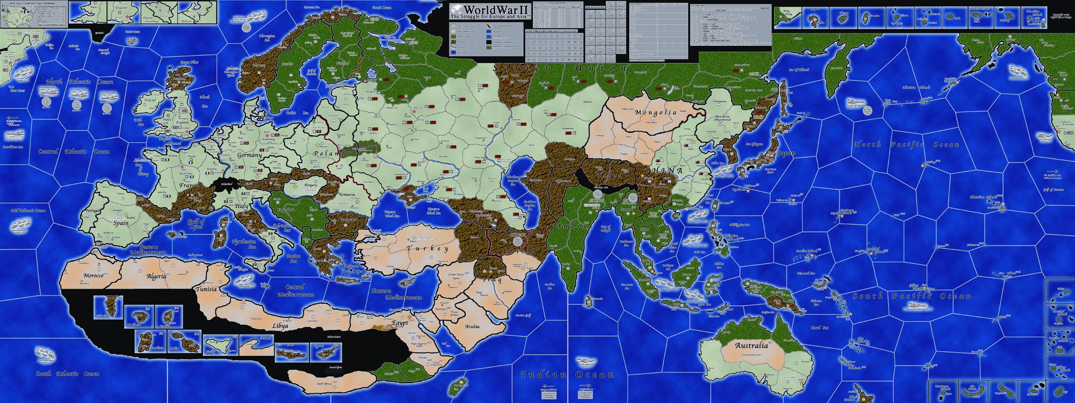
• OK i will fix these. I can do something with Sweden, but my intention was to make it look realistic.

    For whatever reason i cant save them together ( it says not enough memory available) though i got 16 GB of ram and 6 core processor.

    I will try again.


  • umm….this was just the pacific side and it looks the same?


  • I fixed the lines by Malaya and created Western Canada. Also set the cost for AA at 5 IPC on chart.


  • OH I get it - the link tool me back to your old file - I had to click on the new file on the right - duh.

    Looks great! Try to add the guides on the East edge pacific seazones for where the ships come out when leaving that side of the map when you gat a chance.

    Now I just have to build a bigger game room.  :-o


  • The guides are on the Europe map.


  • My table is only 4 x 6…can I print this smaller and still have it be legible/proportional and all that?  I assume the print is larger?  Thanks for any advice!  This will be the centerpiece of my gameroom!!


  • I jumped through the hoops and downloaded these.  These are fan-freakin-tastic!  Wow.  I gotta get these printed…

    Thanks to IL for this.  I now have to decide if I must shrink these for to fit my table/plexiglass (4’ X 6’) or just find a new way to display it…decisions, decisions…plus, I gotta find a sign company to do this bad boy justice…


  • http://www.4shared.com/dir/yVxyAPrp/_online.html

    The corrected file for E40 is here ( look at date for latest file)

    Corrected: 5 cost for AAA gun, two small islands off Turkey were UK color


  • IL - awesome map.  Preparing to print, quick question.  When I opened in Photoshop the sea color is a much darker blue in the Pacific than the Europe map.  Do I have the right files?  I’ll be working to match them up unless I am doing something wrong.  Thanks!


  • Wait to print that. I do have another file where that is corrected. Note that the pacific sea lines are different look, but close enough.

    I will repost the new links soon.


  • Great! Looking forward to it.


  • Hey IL - did you ever make those sea zone corrections?  Thanks!


  • IL do you have versions of this with more territories?
    Ive got an 8x4 in my basement that I am looking for a map to put on it and I like your style and the 1940 proportions, but I would like more territories.

    Almost a global game in the scope of the 1914 map, or in a manner of speaking a France with 6 territories rather than 3.

    Do you catch my drift?


  • Hey IL - did you ever make those sea zone corrections?  Thanks!

    Check the first page of IL’s map’s. I don’t remember that far back.

    IL do you have versions of this with more territories?
    Ive got an 8x4 in my basement that I am looking for a map to put on it and I like your style and the 1940 proportions, but I would like more territories.

    Almost a global game in the scope of the 1914 map, or in a manner of speaking a France with 6 territories rather than 3.

    Do you catch my drift?

    Well i did make Europe 1939, which does have some more areas. I also made a more realistic version of 1940 map file ( the land areas for some areas of Europe look more realistic.

    I can make anything in terms of changes. I just am not dissatisfied enough with OOB to go ahead and do this.  I am against having more areas, because it also means a longer game.

    Was thinking of helping the HBG peeps and make them a new version of that Global 39 thing, but i don’t like all the chrome they put into that.


  • I dont like that thing either. The colors are goofy, the scale is whack. US boats can move from new York to france in one turn.

    I dont have enough Photoshop skills to make a good map myself….


  • The boys at this site have two different versions of their game (basic and advanced) that can satisfy your need for more territories.

    http://www.ww2wargame.com/

    Here is a link to the Europe half of the advanced map:

    http://www.ww2wargame.com/forum/index.php?action=dlattach;topic=302.0;attach=1957

    Attached is a low res version of the the basic games’ full map.

    The different colors in territories represent terrain features which give different defensive values along with other rule limitations.

    WWII Finalv6flatSM.JPG


  • Thats along the lines of what I was thinking, but that art style is wonked out….


  • I have this, I traced the global map and am cutting it up into more territories.
    Not that good at this, and the process is ongoing but this is what I am after.

    Victory cities would be a space unto themselves and “maybe” a special rule that all Infantry defend on ‘3’ during the first round of an attack on a victory city. (to represent it being built up and congested)

    The lines you see are not set in stone, just some fooling around.
    The final board is going to be 8’ x 4’

    Global3.png


  • Dear Imperious Leader,

    Several months ago I got back into AAA with a few friends and decided that our board was wayy too small. After ~an hour of google’n around I found a mighty 190mb pdf and had to turn it into a war-board.

    Here’s the result :-D (although since this picture was taken we have attached sweet bottle opener):

    Without your awesome map this would have never have been possible! THANK YOU!

    After getting more into it, we got the Europe map and soon will get Pacific. We cannot wait to combine the two! However, fast-forward to now, months later I found myself back on google to find that you made MORE MAPS :-o (exactly what I’m looking for)! You are so AWESOME. I just downloaded both and am currently deciding whether to build a second table (maybe with some cup holders and more extra space) or print out a couple more posters to swap-out underneath the plexiglass of the existing board.

    Any tips on how you would set up yours, especially if we were to combine the two games?

Suggested Topics

  • 1
  • 3
  • 1
  • 1
  • 1
  • 21
  • 36
  • 5
Axis & Allies Boardgaming Custom Painted Miniatures

151

Online

17.3k

Users

39.8k

Topics

1.7m

Posts