


they don’t get money, until the capitol is liberated.
France and what should be done about it.
-
I prefer france split like that picture. Make the coastal zones worth next to nothing and the invasion will have to be a real deal rather than 20 various probing fake invasions just to hijack IPC.
-
@Imperious:
I prefer france split like that picture. Make the coastal zones worth next to nothing and the invasion will have to be a real deal rather than 20 various probing fake invasions just to hijack IPC.
Yes, but also the southern part should be split, making France a 6 territory country. Vichy was not adjacent to the Atlantic. As it is in oztea’s pic, a fighter from Italy can sink ships in the Atlantic. Below is s pic of how I think France should be split.
![france[1].PNG](/uploads/_imported_attachments/migrated/50076_france%5B1%5D.PNG)
-
Also, why dont you just lock this thread ?
Soon you will delete all this posts as usual, and lots of information will get lost.
-
Still don’t like the little French map; no territory should border Atlantic & Mediterranean. The Germans quite deliberately drew the border between occupied and Vichy France to have the entire Atlantic seaboard under their control, while VF had all the Med shoreline.
-
i will move the information to a new thread soon.
-
Thanks to IL for moving this….better place for a France Discussion anyway.
Remember too many territoreis is a bad thing…sucks up map and makes takes away from where the board should be REALLY expansive…Russia!Larry said there would only be a 3 territory Germany, France cant be twice the size!
Think of territory sizes as also representing realitive ease of travel (in an abstract way) The less territories and more connections means the area is realitively easy to travel and has alot of the 1940’s equivelent of highways. Russia on the other hand shouldnt be a few big territoreis, it should be a gazillion puzzle peice like quagmires, a keystone territory for moscow that is connected to many territories, to represent how “All roads lead to Rome”…well in this case Moscow.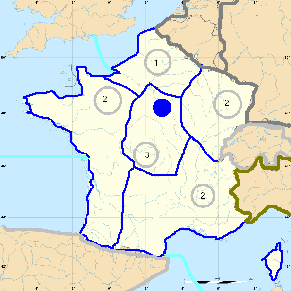
-
Just eliminate the central territory then.
-
why should france have more territories than germany?
-
Because then paris falls in one turn. If I recall correctley, that last image is the exact same shape of France in the original Europe map.
This is 1940, there is actualy going to be a France, and a Battle for France and A “Phoney War”
The map Ive set up makes it hard for France to be defended, but prevents a Knock-out blow in Paris on turn 1 (Germany will likely go first as well)
Also you shouldnt have the Paris territory touch the coast….or the Allies will focus solely on in it based on likeley associated bonuses…or may never attack it, based on weird capital taking rules so each time the Allies attack…they get no IPCs, and Germany taking it back gets a huge bonus of IPCs plus France’s Bank.
-
why should france have more territories than germany?
Germany is “Hyper Industrialized”, especialy compared to France, which im betting will have only a 3 Unit factory. There are less territories in Germany because it is easier for Germans to move from one part of their country to others. Berlin in the East, West Germany, and Southern Germany. Like how the US is only 3 territories, and West Russia is like 7. they are both huge expanses of land, but in the case of the US there are more Railroads, roads, bridges, etc.
-
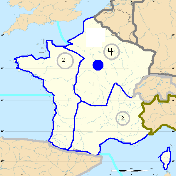
I like the five territory france, and of course vichy france should not border the atlantic.
-
And occupied France should not border the Mediterranean…
The Paris problem is solved if you delete the ridiculous capture the capital rules (Larry - It ain’t gonna happen)
The size of spaces problem is solved if you have rail movement in non-combat (Larry - It ain’t gonna happen)
The repeated trading of France problem is solved if you collect income first (Larry - It ain’t gonna happen)
I’d go with the 3 territories, though I would give “Eastern France” a coastline. The Allies would’ve been in Paris sooner had they landed here rather than Normandy. Paris IS in north-east France; Moscow is in eastern Europe; so should they be on the A&A map.
-
i think there needs to be two coastal territories that dont include Paris, to better reflect the Cherbourg (Dieppe + Dunkirk) vs Normandy + Atlantic Coast cannundrum. Also a territory in the south, (Vichy) as a location for Operation Dragoon and for the Italians to invade(Represents Vichy Government in the long run). And a Maginot area that makes Germany have to take out the Netherlands to force the allies to defend two territories rather than 1 from blitzkreig. If its going to take more than one turn to fall, and its going to be fun to take back, it has to be 5 territories.
France and UK start with enough in France to defend 1 territory solidly, but not two. They can pull back to Paris….if Germany doesnt crush both locations turn 1, but it devovles into a WW1 Situation.
-
Guidelines To Making a Three Territory France: Vichy France, Western France, and Eastern France
1. Start with these historical demarcations as a baseline:
http://en.wikipedia.org/wiki/File:France_map_Lambert-93_with_regions_and_departments-occupation.svg
*Notice Vichy France does not boarder the Atlantic.
2. Draw a line that starts between where the Historical Provences of Brittainy and Normandy meet (around where the Normandy and Brittainy peninsulas meet at the tip of the Gulf of St-Malo) and runs aproximately 45 degrees clockwise from the horrizontal axis to Vichy. This will serve as the rough boarder between Western France and Eastern France.
3. Shrink Vichy France: The boarder Between WF and VF should start in the middle of the French-Spanish boarder and run roughly north toward Paris. This gives units in WF more room.
The Triterritory-Axis should lie aproximately in the middle of France, giving you three territories about equal in size.
*Note on Eastern France: the Pas-de-Calais should be part of Belgium to allow for two alternate Allied strategies:
A. Eisenhower’s Normandy landing to take France first, or
B. Patton’s Reverse Schlieffen Plan to land at Calais and make a B-line for Berlin
-
If you want more territories, add Paris:
the origional is also a good baseline:
http://www.boardgamegeek.com/image/68400?size=original
However, like I said, the northeast territory should include all of the historical Normandy province.
West France is to act out the diversion landings on the west coast.
Calais should be grouped into Belgium-Netherlands.
So there are your five territories: VF, WF, EF, + Paris + Netherlands (Netherlands will play a big part on the Battle over France).
-
the origional is also a good baseline:
Thats not the original. LMFAO!
-
@Imperious:
the origional is also a good baseline:
Thats not the original. LMFAO!
… :-o
your right, it’s AAE Advanced. It’s your creation, right? +1 I wonder what it was doing on BBG for regular AAE? Anywho, my mistake.
Here’s the origional:
-
It’s your creation, right? +1
no but i think they got this map from a poster named “frog” where all ideas come from.
:-D
You may ask who is this Frog?
I will answer you. i have no idea.
-
Frog…… :|
Do I even want to know?
-
I still think that 6 and 5 are too many
At most 4, but 3 is better.
Also, i do think that paris should be taken on the first turn, this is 1940 after all.
Here is my second map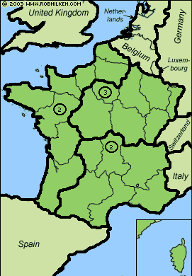
Suggested Topics

