https://www.seawarstore.com/NavalEnsignsDlx.htm
This site offers dedicated military flags that are placed on the table for each player.
This post will be dedicated to present the project I am working on for several months and that I humbly decided to name Ironclad, after the the allied operation to capture Madagascar in May 1942.
This name reflects the addition of Vichy France and the Commonwealth, as well as the emphasis on amphibious assaults I tried to put in this variant of the 1942 scenario of the Anniversary version of the game.
It is played on a modified circular map (azimuthal equidistant projection about the North Pole) that I initially presented and discussed here:
https://www.axisandallies.org/forums/topic/39054/custom-map-for-aa50
It is played without technologies and national objectives, but with a few additional house rules and with 3 optional new powers : France, the Commonwealth and Neutrals (each of them coming with a set of specific rules). The idea is that players can choose to play with or without (one or all of) them, depending on the kind of game they want to have.
I created a (still unperfect) mod on TripleA to test these ideas, and I’ll be glad to share a beta-version if anyone is interested.
The map
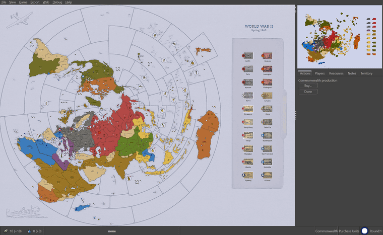
So, let’s start with the map:

It is circular (mostly for fun - as it is for sure not the most convenient projection for an AA style game) and slightly more historically accurate than the original map, with reviewed territory borders, alternate names and some details (including lot of islands!) not used in the game. This is a personnal choice that can be challenged - but I think that I managed to keep it overall playable.
Oh yeah, and Italians turned purple because I kept confusing them with others ;)
Territories
There are a total of 125 territories (vs. 97 in AA50). These additions are a mix of historical accuracy and gameplay modifications, and most of them exist in other versions of the game.
Several islands have been added as well, mostly to expand the Pacific theater of the war. I chose to standardise the nomenclature to differentiate between the short list of strategic islands (hosting naval / air bases) - the only ones considered as territories - and their archipelagos. This way, Truk Atoll replaces the OOB territory of Caroline Islands. Islands considered as territories are drawn in bubbles on the map to avoid confusion. I also removed IPC values for all islands (with the exception of Madagascar, New Zealand and Hawaii) to better represent their only strategic (vs. industrial production) role.
Sea zones
The number of them is kept (almost) unchanged (66 vs. 65), but many connections have been modified to adapt to the projection change and new territories, as well as for some chnages in the gameplay. Northern America is a bit more isolated: a ship can no longer reach Northern Africa or the British Isles from the East Coast in one round only. In the Pacific, Guadalcanal is no longer two moves away from US coast. This, again, to promote the need of islands captures.
Victory cities
Cairo (Egypt) and Singapore (Malay States) are added as victory cities, and victory conditions are changed accordingly:
Straits
Straits have been added and work the same way canals do.
Naval bases
Having the main naval bases of WW2 present on the map was one of the main objective of my initial project. In the game, they work as permanent infrastructures (cannot be built or destroyed) that are captured together with the territory they belong to. In order to move their regular two spaces, ships need to have a friendly naval base adjacent to their initial sea zone. Otherwise, their movement is restricted to only one space. This major rule drastically change naval warfare and makes island hopping much more important than in the original game. Additionnaly, AA gun can “scramble” from territories with a naval base (coastal artillery), making AA gun transport useful in some situations and weakening the overpower of planes.

Royal Navy and Kriegsmarine bases in the North Sea.
France
France is added as a special neutral (axis aligned) power. These rules are an adaptation of those posted by Dragon81 there:
https://www.axisandallies.org/forums/topic/32430/axis-allies-anniversary-upgraded-version
At the beggining of the game, France still controls a couple of territories (Southern France and some colonies) with few land units but an almost intact mighty fleet. Free France is not represented and is considered as controlled by UK.
French units don’t move and ships are considered stationned in the ports, so they don’t block other players movements.

French aircraft carrier “Béarn” stuck in Martinique
Invasion by the Allies
Each round, any allied player can decide to invade one or more French territories. This decision should be communicated at the beggining of the Combat Move phase, and all French units become immediately hostile to that player. French land and sea units defend against any attacks, including amphibious assaults (dices are rolled by any Axis player). After the battle, if the territory has been captured, the fate of any remaining French fleet on the adjacent sea zone is decided according to the following rules:
After Non-Combat Move phase, France returns to its full neutrality.
Occupation by the Axis
Axis powers can move into/through French territories during Non-Combat Move (but cannot cross/can fly over during Combat Move). At any time in the game, any Axis player can decide to occupy Vichy France and to try to seize their fleet. The decision should be communicated at the beggining of the Combat Move phase. The Axis player can then move into any French territory during that phase. French units don’t defend against this occupation. After the Combat phase:
Liberation of France
At the beggining of the British turn, if Paris has been liberated (France controlled by Allies), a regular French turn is permanently added to the game (with the same phases than all other players). France is played by the British player as another separate allied power. He takes immediate control of all remaining French units on the board and place French markers on France and any territory considered as initially French and occupied by the Allies (Southern France, Algeria Tunisia, Morocco, French West Africa, French Equatorial Africa, Madagascar, French Indo-China, New Caledonia, Bora Bora and French Guiana). For the rest of the game, France is handled as any other Allied powers (same rules apply in case its capital is occupied again, etc.)
The Commonwealth
The Commonwealth can be added as a separate player from the United Kingdom. It comprises Canada, Australia, New Zealand and South Africa (6 territories, 10 IPCs), as well as the territory of Papua (no IPC value). It will never grow bigger than that, as Commonwealth troops conquer new territories on behalf of UK. It has no capital and can produce units as long as it controls at least one of its core territories. It has no factories and cannot build any, but units can be placed on any core territory (and adjacent sea zones) with the limitation of 1 unit per IPC value of the territory.
The Commonwealth play first in the game (before the Japanese), which may well upset the usual opening strategies of Germany and Japan.

New Zealand has been buffed with a fighter and a cruiser… But they are so far… (newly added Sea Zone 66 is partially out of the board)
Billion Dollar Gift
Each round, before Purchase phase, the Commonwealth can decide EITHER to give ALL their IPCs to the United Kingdom (who can use it directly during their turn) OR to use them for national production.
Save the Empire
If London falls to the Axis, and if the Commonwealth still controls at least one of its victory cities (Ottawa or Sydney), they collect additional IPCs for all territories still controlled by UK at the end of their turn. This money can be used to produce units (but the same restrictions regarding placement of units apply).
If London is later liberated, money collection reverts to normal rules.
Neutral powers
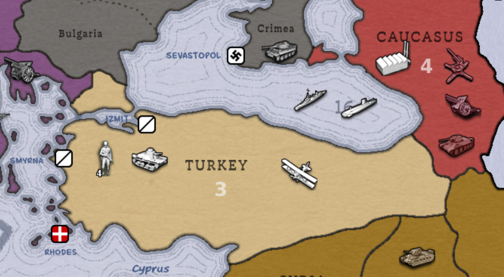
Neutral powers are countries that haven’t (yet) joined the war. They have their own armies, fleets, IPC values and naval bases. There are no more impassable territories, but some connections between territories are instead forbiden (in the Alps, the Sahara, the Himalaya and around Mongolia). As in the original game, neutral territories cannot be crossed by land units, nor flew over by aircrafts.

Axis (and Soviet) agression
Only Axis players are allowed to invade neutral countries. Each player can decide to launch one (and only one) invasion at the beggining of the Combat Move phase. The attacked territory joins then immediately the Allies side under British command (or Commonwealth in the case of Ireland). All land and sea units defend as if they were normal British (Commonwealth) units. If the invasion doesn’t succeed, the territory and its units remains British (for IPC collection and other purposes). The list of territories that can be attackedthis way is the following:
The Soviet Union can invade the two neutral territories with which it shares direct borders (Afghanistan and Turkey) following the same rules. In this cases, these territories are considered under German control for battle resolution and for the rest of the game.
Iberian Gambit
Spain and Portugal (and their colonies) are in the middle of a special game between Axis and Allies. UK or USA can persuade Portugal to join their side, but this provokes Spain to immediately join the Axis side (under German command). Italy and Germany can do the opposite: rallying Spain and pushing Portugal to join the Allies (under British command). The “gambit” is announced by the player at the beggining of the Combat Move and can be followed by invasion moves into the concerned territories.
Latin America at war
The three neutral territories in South America cannot be directly invaded. Instead, they all immediately join the war if any Axis player lands troops in continental America (from Alaska to Brazil, excluding the islands).
Soviet–Japanese Neutrality Pact
(special rules for Mongolia - still under playtesting)
@Azimuth Here from the TripleA forum, because I would very much like to try this out
@jkprince thank you for your interest ;)
If you send me an e-mail address or alike, I’d be glad to share the folder for a “beta-version”
Hello!
Thanks to a fruitful discussion with @Black_Elk, I managed to solve the zoom issue I had because of the square format of the map. It is now possible to display the full map on the screen. And as I gained some extra empty space on the right, I implemented… the victory cities board of stamps!

Isn’t it neat?
Well, I should still work on it, because it’s hard to find the right balance for transparency. But it is working well: see below examples on how Singapore’s stamp is changing depending on whom managed to occupy the city ;)


@Azimuth F yea looks good !
Did you upload to triplea ? Not seeing it.
There’s a ton of WW II maps. Maybe rename to “Spring 1942 Ironclad WW II” or some such. Might stand out a bit more. Then again, it could have the opposite affect lol
Nice job :)
@barnee Thank you :)
No I haven’t uploaded it yet, but I shared the files with some people. There are still a lot of details to clean (it’s endless…)
I am developping two games using the same map, “Ironclad” and “Fall Blau” (further modded, with a reviewed units roster) - so the name on the map is very generic, with the idea that the name of the version will be displayed dinamically below. But this is still WIP.
@Azimuth You should add the Vichy Hammer on the roundel.
@CentralCommando Vichy France’s official flag remained the normal tricolour.
Also, France switches back to the Allies once their country is liberated, so it’d just cause confusion
@jkprince Ah, alright.
@jkprince indeed 🙂
Thank you both for your interest!