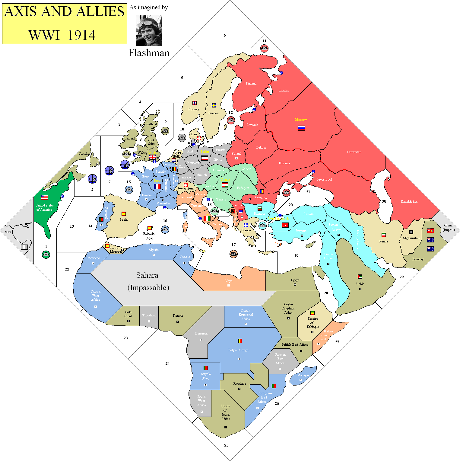
I’ve created a separate thread for my work on the OOB 1914 map. Please go here to discuss it in more detail.
Images of the Map?
-
Just touting for suggestions on terrain effects in regard to the terrain map posted above:
Mountains: Tanks cannot enter; Artillery fire -1, Air observation limited - only one artillery promoted for each surviving aircraft.
Jungle/Forest: Tanks cannot enter; Artillery fire -1, No air observation.
Desert: Unit limit, say 8 units? (water in short supply) After every player turn reduce units to 8 maximum. If units of more than one power are present, each reduces one unit until limit is no longer exceeded. Each must leave an infantry as per battle casualties.
-
What do the flags represent on your map Flashman?
-
The large flags are the player capitals, small are neutral capitals.
-
No, not the national flags, the other flags you had on various border territories?
-
I did one map with lots of small flags for aspiring nations, to do with what happens when an Empire collapses.
Also there were some small tribal groups such as Senussi and Basmachi.
-
Latest Bells & Whistles map.
Still can’t make out the Turkish SZs.
Some minor changes in Africa.
Is it possible that there is just one SZ surrounding Britain?
-
I know I missed it somewhere, but are the colors for each nation listed?
-
I know I missed it somewhere, but are the colors for each nation listed?
Not sure if they are listed anywhere…
But this image of the map clearly shows the colors.
http://www.wizards.com/ContentResources/Wizards/Sales/Solicitations/2012_12_19_AA1914_Solicitation_en_US.pdf -
But I am color blind, that’s no help!
-
As it happens, so am I - I cannot therefore be accountable for the colours used on the map, especially the greens. In fact, I’m by no means certain the colour I’ve used for the USA is green.
Italy is meant to be orange, but when the pic is posted here the palette somehow changes it to pink.
-
The “Great Russia” border is to do with possible Revolution rules.
It looks really silly that the borders of SZ 17 & 19 don’t meet at the Libya/Egypt border, probably do do with how skewed the board’s projection is.
I’m concerned about the Allies invading Persia and Norway to supply Russia; if they’re allowed to do this it could be a game breaker.
If control of mines changes with that of the naval bases we’ll need mine control markers…
-
We’re nearly there. IPC values and maybe a couple of minor border changes.
SZ 18 is absurdly small, I’m guessing this is to stop Austria transporting units across to Naples.
-
Nine player game, anyone?
-
Are you suggesting Spain as a ninth player?
I see no other added power, but that is disastrously ahistorical. What can you possibly mean -
Sweden
-
Just an idea. I think Spain is massively underpowered as a neutral. If it really does have only 1 IPC that makes it half as productive as Albania, which had no industry whatsoever.
I’d certainly give it a few more IPCs and a navy off Cadiz.
Are you suggesting Spain as a ninth player?
I see no other added power, but that is disastrously ahistorical. What can you possibly mean -
Just an idea. I think Spain is massively underpowered as a neutral. If it really does have only 1 IPC that makes it half as productive as Albania, which had no industry whatsoever.
I’d certainly give it a few more IPCs and a navy off Cadiz.
And the power to unleash the Spanish Influenza.
-
And the power to unleash the Spanish Influenza.
Ha! Roll two die per unit. “Snake eyes” means death.
Yrs.,
R. -
-
Here’s a printer-friendly version of the map Flashman uploaded, for those of you who’d like to playtest the map without using a gallon of cyan.
Yes, it’s a little “Easter-y,” and we’re still missing many of the IPC values, but if you want to get a rough feel for how the game plays, here you go.
P.S., If someone can figure out how to format this so it prints out on 8.5"x11"'s, that’d be awesome.


