Well you can use almost any photoshop program.
GIMP for example is a free photoshop program.
In order to make a custom map you get yourself an empty template with the dimensions of the map that you want to create, let’s say for example the Global 1940 map.
Then you import the official 1940 map, as an overlay.
Make it blend in with your empty template so that you can see both and then start drawing. 🤷♂️
Then you can basically draw the borders, landmass etc.
You can take it anywhere from there, it’ll all depend on your skill with the program and your own style!
Best posts made by SGT. GENTLEMEN
-
RE: What are your tips for making custom axis and allies boards?posted in Customizations
-
[1914] Working on a custom map!posted in Customizations

Hello everyone,
My name is Sergeant gentlemen, and I wanted to show off the custom map that I’m working on.
I’m very new to Axis&Allies.org, so if there is something that I’m missing in this post please let me know.I’m showing this off in order to get some feedback in any way possible.
The map itself is in it’s very early process.
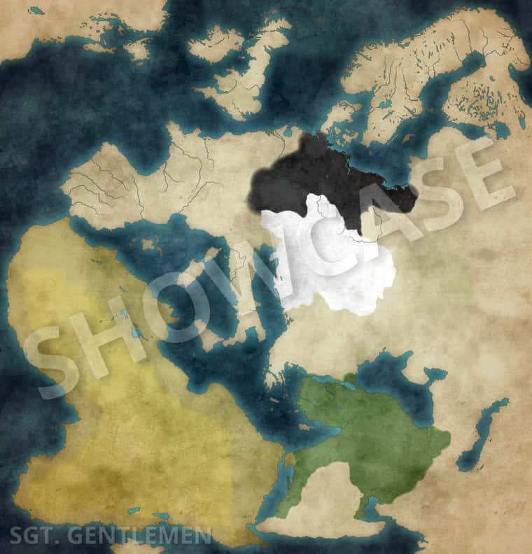
Currently I’m done with all the landmass.
I’ll definitely add more details to the land, like lakes, rivers, trees, mountains, etc.
My custom map is gonna be a more realistic type of map.When all the land stuff is done I’ll begin to add the borders, provinces, etc.
I quickly did some coloring for the Central Powers to show off the colors that I might want to use.
Germany black as always, and as for Austria Hungary… well seeing Austria Hangary having a white color in the hoi4 game, surely made it interesting for me to try it out.
I also think the green color fits with the Ottoman Empire, maybe a red color would also work, but then again, I’m open for suggestions.I’ll be updating you guys on the map.
SGT. Gentlemen.
Latest posts made by SGT. GENTLEMEN
-
RE: What are your tips for making custom axis and allies boards?posted in Customizations
Well you can use almost any photoshop program.
GIMP for example is a free photoshop program.
In order to make a custom map you get yourself an empty template with the dimensions of the map that you want to create, let’s say for example the Global 1940 map.
Then you import the official 1940 map, as an overlay.
Make it blend in with your empty template so that you can see both and then start drawing. 🤷♂️
Then you can basically draw the borders, landmass etc.
You can take it anywhere from there, it’ll all depend on your skill with the program and your own style! -
RE: What are your tips for making custom axis and allies boards?posted in Customizations
Currently working on one, for 1914 that is.
-
[1914] Working on a custom map!posted in Customizations

Hello everyone,
My name is Sergeant gentlemen, and I wanted to show off the custom map that I’m working on.
I’m very new to Axis&Allies.org, so if there is something that I’m missing in this post please let me know.I’m showing this off in order to get some feedback in any way possible.
The map itself is in it’s very early process.
Currently I’m done with all the landmass.
I’ll definitely add more details to the land, like lakes, rivers, trees, mountains, etc.
My custom map is gonna be a more realistic type of map.When all the land stuff is done I’ll begin to add the borders, provinces, etc.
I quickly did some coloring for the Central Powers to show off the colors that I might want to use.
Germany black as always, and as for Austria Hungary… well seeing Austria Hangary having a white color in the hoi4 game, surely made it interesting for me to try it out.
I also think the green color fits with the Ottoman Empire, maybe a red color would also work, but then again, I’m open for suggestions.I’ll be updating you guys on the map.
SGT. Gentlemen.
Suggested Topics


