


I’ve created a separate thread for my work on the OOB 1914 map. Please go here to discuss it in more detail.
Images of the Map?
-
Agree with you Thrawn not to mention your scenario for Bulgaria was probably more historically accurate. I also don’t like the fact they can only put units out once. Maybe if you don’t take it that country can reinforce with half of what it started with. Example Austria invades Romania. Romania starts with 3 inf and 1 art. If they survive they reinforce it with 2 inf. If it still holds 1 inf. If every other country continues to reinforce why can’t these smaller ones. They should be able to just on a smaller scale. Bulgaria when it joins the Central should act in a similar fashion.
-
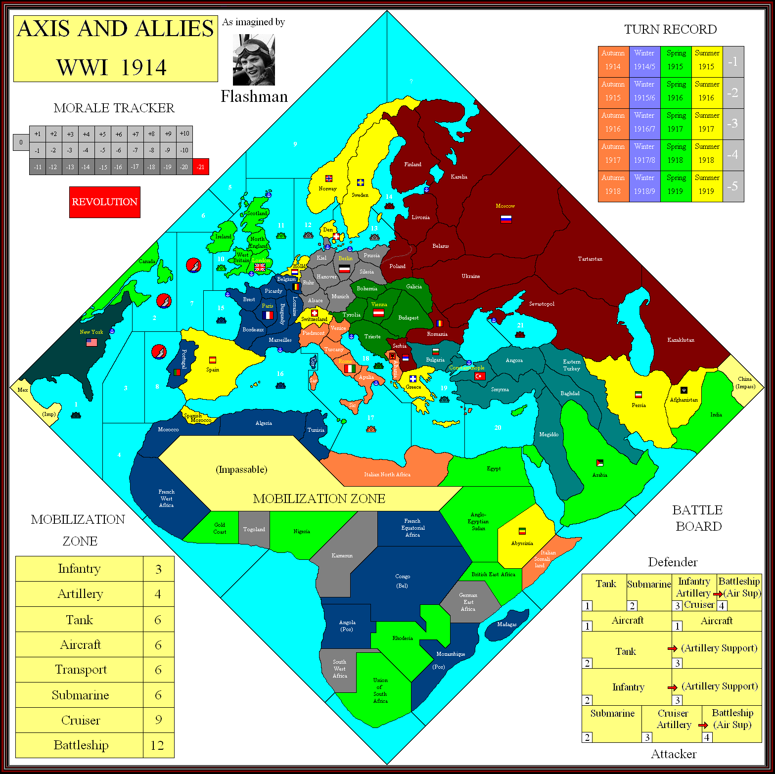
When I started this map I used Diplomacy tt names, as that seemed to be the way they’ve done it - Austrian and Russian tts are virtually identical.
Turkey seems to be somewhat different, with this weird long tt stretching from Georgia to the Persian Gulf. Can’t really call it “Armenia”, so Western Turkey it is. Again, its one of those I hope I’ve got wrong and the real map is more logical.
Yes, Bulgaria might be German controlled, but I think that the proximity to Turkey is the decisive factor; just as Russia can support Romania and Serbia, and France Belgium. Presumably Portugal is French to create a balance in Southern Africa.
Regarding placement, I’ve posted on another thread the suggestion that infantry can be placed away from the capital. In this case, such countries as Bulgaria and Belgium would in effect become part of the controlling power, so you can place infantry there subject to certain limits.
Albania is a strange case; I’ve been unable to find evidence of Italian control there before 1917. I think I’m correct in assuming they’ve simply absorbed Montenegro into it to make it a reasonably sized tt.
The weird kink in SZ boundaries to place Corsica in the French zone is unexplained.
Switzerland being active does make me wish certain tts were designated “difficult” terrain for attackers.
But above all, the unhistorical Poland spoils the map. We have to assume that there is a vital game play reason for it; stop Germany blitzing up the Baltic coast?
Anyway, map update: German borders adjusted after re-reading the Imperial Germany report. Munich and Silesia may be connected as per Diplomacy.
Q: Are American and Italian minefields active before they go to war? If so, do they “attack” shipping from both sides?

-
Turkey seems to be somewhat different, with this weird long tt stretching from Georgia to the Persian Gulf. Can’t really call it “Armenia”, so Western Turkey it is. Again, its one of those I hope I’ve got wrong and the real map is more logical.
But shouldn’t it be Eastern Turkey or is it designed to drive fans of cardinal directions up the wall?
-
I apologize if I come off as some sort of AAO Mary Whitehouse, posting a response everytime I think someone has gone too far in pushing the boundaries of the cardinal directions.
-
Ahhhh, I see: East is West.
I think this came about because I originally had a “Western Armenia” tt there.
That’s my story and I’m stuck with it.

-
Sevastapol and Eastern Turkey might be the two most awkward adjacent territories an A&A history, if the clues led to the correct interpretation.
-
Latest Update.
I now think there may only be one Turkish SZ, covering both sides of the straits.
Can’t see the top of the map, but this may be important for the Allies dropping units into Karelia to support Russia.
They’ve probably followed Diplomacy in calling Western Britain “Wales”, but this would be correct only for a game set in the 7th century.
Got rid of the Colonial NBs, simply because I don’t think even Larry and his men would allow battleships to be built in these places.
This leaves us with:
New York
Scapa Flow
Portsmouth
Brest
Toulon
Taranto
Pola
Constantinople
Sevastopol
Kronstadt/PetrogradKiel
StettinArguably Kiel should cover the Baltic, with Wilhelmshavn the North Sea; but I doubt they would want both German bases located in the same tt.
Of course Konigsburg is another candidate for the Baltic NB, but seeing as L & Co have given it to Russia 31 years too early…

-
Variable terrain types version:
Tanks cannot enter mountains and jungle.
Aircraft restricted in jungle, possibly mountains.
No trains in the desert.

-
might be a stupid question, but with Belgian and portuguese colonies… do they get troops aswell if invaded? So 1 INF 1 ART per country (moz, ang, congo)…
-
I would assume they’re 1 IPC tts, though Congo has large mineral deposits that might bump it up to 2.
Larry didn’t mention their troops when reporting on France, so presumably they are not placed until either:1. A French unit enters them.
2. A CP unit attacks them.
This creates the anomaly that, for example, UK units are allowed to invade non-aligned Abyssinia, but cannot enter Portuguese Mozambique, even though it is supposedly pro-Allied.
I would have though that France at least gets to collect income from these colonies, as in effect Belgium becomes part of France when invaded. But it doesn’t seem so.
-
Just touting for suggestions on terrain effects in regard to the terrain map posted above:
Mountains: Tanks cannot enter; Artillery fire -1, Air observation limited - only one artillery promoted for each surviving aircraft.
Jungle/Forest: Tanks cannot enter; Artillery fire -1, No air observation.
Desert: Unit limit, say 8 units? (water in short supply) After every player turn reduce units to 8 maximum. If units of more than one power are present, each reduces one unit until limit is no longer exceeded. Each must leave an infantry as per battle casualties.
-
What do the flags represent on your map Flashman?
-
The large flags are the player capitals, small are neutral capitals.
-
No, not the national flags, the other flags you had on various border territories?
-
I did one map with lots of small flags for aspiring nations, to do with what happens when an Empire collapses.
Also there were some small tribal groups such as Senussi and Basmachi.
-
Latest Bells & Whistles map.
Still can’t make out the Turkish SZs.
Some minor changes in Africa.
Is it possible that there is just one SZ surrounding Britain?
-
I know I missed it somewhere, but are the colors for each nation listed?
-
I know I missed it somewhere, but are the colors for each nation listed?
Not sure if they are listed anywhere…
But this image of the map clearly shows the colors.
http://www.wizards.com/ContentResources/Wizards/Sales/Solicitations/2012_12_19_AA1914_Solicitation_en_US.pdf -
But I am color blind, that’s no help!
-
As it happens, so am I - I cannot therefore be accountable for the colours used on the map, especially the greens. In fact, I’m by no means certain the colour I’ve used for the USA is green.
Italy is meant to be orange, but when the pic is posted here the palette somehow changes it to pink.
Suggested Topics

